Mount Belukha (Altai Mountains)- the highest point of Altai, its symbol and one of the most beautiful peaks on the continent of Eurasia. This is a place of pilgrimage for many tourists engaged in ecological, extreme and esoteric tourism. Magnificent nature, steep mountain slopes, legends about shamans and a lot of beliefs local residents who revere Belukha as a sacred place, make this mountain ideal option for travel at any time of the year and for people with a variety of purposes.
A little history
The earliest official data about Belukha dates back to the end of the 18th century. The first attempt to conquer the peak was made by the British traveler Samuel Turner only in 1904. The Tronov brothers managed to climb it only in 1914. The Altai Mountains (Belukha in particular) have always been inaccessible, and getting into their possessions is very difficult.
Scientific research into the surrounding lands began in the second half of the 19th century. In 1835, the local flora was studied by the naturalist F. Gebbler, who managed to discover the Katunsky and Barelsky glaciers. He was the first to try to determine the height of the mountain using a protractor. According to his calculations, the height was 3362 m, but this turned out to be incorrect.
The second to find out the height of the mountain in 1895 was Professor V.V. Sapozhnikov, and he determined the mark at 4542 m, however, this was also erroneous. The true height of Mount Belukha (Altai Mountains) is 4506 m - it was correctly established in 1948, but by what method is unknown. By the way, in 2012 new studies were conducted that showed a different height - 4509 m. Now modern maps indicate two different heights, differing by 3 m.
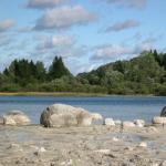
A holiday on Mount Belukha is a holiday in, because it has always had the status of a sacred place and was deeply revered by indigenous peoples. Altaians call the peak “ Ӱch-Sumer", which means "Three-headed peak". This is exactly how Mount Belukha appears to the eye - the photos clearly demonstrate this. The Altai region annually attracts thousands of tourists, and many of them go to the foot of the “Three-Headed River”.
We invite you to watch a few photos Belukha Mountains in Gorny Altai:
What to see and do
Excursions and tours to Mount Belukha are very popular. Hiking, trekking, climbing from the foot to the top give travelers not only wonderful photographs, but also impressions and emotions that last a lifetime.
Vegetation and animal world this place. The forest belt alone rises up to 2000 m, and higher up are treasures of medicinal herbs and the charm of colorful shrubs. In total, about 30 species grow on the slopes of Belukha rare plants, including Krylov's cinquefoil, Rhodiola rosea and Ukok larkspur.
You will also be surprised by the wildlife of this place - Mount Belukha (Altai Territory) is home to lynx, mountain goat, snow leopard, zokor and other animals. But what is most striking is the variety of birds. Here you will see large lentils, golden eagles and Altai snowcocks listed in the Red Book, alpine jackdaws, tundra partridges and juniper grosbeaks.

But a holiday on Mount Belukha is also active entertainment. Mountaineering, horseback riding and hiking tours are held in its area. There are several trekking routes of varying difficulty. Professionals and amateurs can try their hand at climbing Belukha. There are several options for lifting from categories 3A to 4B. Those who prefer a more relaxed holiday can simply be in nature, enjoy the beauty of high mountains and the sound of fast rivers, wander along the slopes, sit by the fire under a myriad of stars or at dawn. 

To get at least a little closer to the new journey, watch this video of Mount Belukha in Altai:
How to get there
We tell you how to get to Belukha by car and without a car. Easiest way to get there by train to Barnaul, then sit on bus to Gorno-Altaisk(about 260 km) and change trains by bus or taxi to the village of Tyungur(about 380 km). A hiking trail (50 km) leads from the village to the mountain.
Buses from Barnaul depart from the bus station (Victory Square, 12A). You can also leave from Gorno-Altaisk to Tungur from the bus station (Kommunistichesky Prospekt, 55). In Tungur, anyone can tell you the best way to get to Belukha, and there are also signs. In Tungur you can book excursions and tours to Mount Belukha, try to find a shaman and make friends with the Altai people.
Those who want to drive up to the mountain in their own car will find it useful GPS coordinates: 49°48’26.7″ 86°34’53.5″
Where to stay
Holidays on Mount Belukha are also pleasant because there are many tourist centers and tourist complexes, guest houses and estates in the area of the mountain. “Ark”, “Vysotnik”, “Uimonskaya Pearl”, “Belukha Portal”, “Altaina”- just a few shelters for the traveler. There is even a health center "Ason's Key", where you can wander around the maral and take an antler bath.
Almost everywhere you can make a fire, fry meat or zucchini on a grill, or put up a tent if you don’t want to live in a room, house or village. The hosts always warmly welcome guests and do not refuse to help. Some tourist centers offer a wide range of tourist services: from hiking and rafting to climbing to the top of Belukha and speleological tours.
When to go
The weather on Mount Belukha should always be taken into account when planning your trip. The climate here is quite harsh: cold (up to -30°C) long winters and short (up to +20°C) summers with heavy rainfall. At the top of the mountain, even in summer it can be -15°C -20°C. By the way, there are more than 160 glaciers in the mountain area. The best time Summer months are considered for travel: from the end of June to the end of August. Extreme sportsmen also travel in winter.
A holiday on Mount Belukha is something for which you should prepare thoroughly. It is necessary not only to stock up on a wide variety of clothing and provisions, but also to acquire equipment if you are planning a serious or long route. If this is not a hindrance for you, the places of Power will reveal several of their secrets to you, and the trip itself will be firmly imprinted in your memory and in the photo.
Mount Belukha is rightfully considered one of most beautiful places and one of the world's natural heritage located on the map of Russia. Reaching 4509 meters in height, it is the highest point Gorny Altai.
The mountain got its name from its luxurious snow-covered peak. The Altaians called it “Katyn-Bash”, which means “the source of the Katun” or “Ak-Su-Ryu” - “White water”. Residents of Kyrgyzstan gave it the name “Mousse-Du-Tau”, which translates as “Ice Mountain”. Its sacred name is “Uch Sure” or “home of the gods.”
Thanks to her amazing energy, Belukha became sacred place Altai mountains not only for the locals, but also for the hundreds of people who visit this place every year.
Mount Belukha on the map of Russia is located in the Altai Republic (Ust-Koksinsky district), close to the Russian-Kazakh border.
Coordinates:
- 49°48′25″ north latitude.
- 86°35′23″ East longitude.
You can get to Belukha:
- By public transport : Barnaul – Gorno-Altaisk – Tungur. In order to get to Barnaul it is easier and more comfortable to use the train. Then get to Gorno-Altaisk by bus. From there, either take a bus or a taxi to the village of Tyungur, from which there is a walking trail and signs to the mountain.
- By car: Chuisky tract - Seminsky pass - Ust-Koksa - Tungur. After the Seminsky Pass, at the intersection you need to turn right following the sign for Ust-Koksa. The village of Tyungur is located 60 km from it.
The emergence and development of Mount Belukha
Mount Belukha is formed by sandstone and shale of the Cambrian period and volcanic deposits of the Devonian period. During the Cambrian - about 520 million years ago - the modern territory of Mount Belukha was a shallow sea with underwater active volcanoes, due to the action of which rocks of quartz, chalcedony and other minerals appeared.
At this time, the first uplift of rock in the Katunsky Ridge zone above sea level and the formation of deep faults occurred. 460 million years ago, this area again sank under water, so that in the Ordovician period (420 million years ago) it began to rise to the surface, while the Katunsky ridge was greatly modified under the influence of water currents.
The uplift of the rock occurred over millions of years and in the Devonian period (360 million years ago), troughs with deposits of carbonate and volcanic rocks continued to form along the ridge. During the Mesozoic period (70-225 million years ago), the terrain actively developed: under the influence of tectonic movements, wind and water, rock was transported to lower areas of the area and accumulated there.
In general, the area looked like valleys with hills scattered throughout them different sizes and resembled a modern Kazakh small hill.
1 million years ago, tectonic movements began along deep faults, which led to the rise of rock to different levels of height and recently horsts and grabens appeared on relatively flat valleys, one of which was the Katunsky ridge.

The uplift of the rock continued for centuries, and was accompanied by extensive glaciation of the area. Glacier activity led to the formation of moraines, troughs and cirques and greatly influenced the formation of modern mountainous terrain. Today, the territory of Mount Belukha remains seismically active; tremors occur periodically, which continue to change the topography of this area.
History of the study of Mount Belukha
The first description of the mountain was made in 1793 in the notes of P.I. Shangin, who relied on the stories of local residents. In 1833 F.V. Gebler, a doctor working at the Kolyvano-Voskresensky factories, organized a trip to confirm rumors about glaciers in this area.
During his journey, he found an ice stream, the source of the Katun, saw a mountain and even climbed the Katun glacier, which received its second name in honor of him - the Gebler Glacier. It was F.V. Gebler, based on his studies of Mount Belukha, mapped the features of its terrain on the map of Russia. In 1880, the mountain was visited by N.M. Yadrintsev, a famous scientist who specialized in the study of Altai.
Professor and good climber V.V. Sapozhnikov made a great contribution to the study of Mount Belukha. In 1895, his first journey took place, during which he managed to climb to a height of 2860 m. In 1897, the second expedition ended with a return from a height of 3000 m.

Sapozhnikov V.V. I approached the mountain from different sides and recorded 4 large glaciers, 9 medium glaciers and many hanging ones. His third voyage took place in 1898. As a result, he managed to climb the saddle of the mountain along the Katunsky glacier. In 1914, after three unsuccessful attempts, the Tronov brothers became the first to reach the eastern peak of Belukha.
In the same year, the expedition of N.V. took place. Novikov and A.V. Lepekhin, after which the exploration of the mountain was suspended for the duration of the revolution. After the revolution, researchers from Tomsk and Novosibirsk begin working on the mountain.
In 1924 in New York, N.K. Roerich, together with like-minded people, formed the Belukha corporation, which was engaged in research, searching for ores and minerals, creating energy and transport routes communications, real estate and agricultural and business development in the Belukha Mountain area. Thirty thousand shares were sold.
In 1926, the corporation reached an agreement with the Soviet government, but since work did not begin until 1929, it lost the right to them. In 1925, the first tourists came to Belukha. 19 people, including doctors, government officials, teachers and students, studied the Gebler Glacier for one day.

Attempts were made to climb the mountain in 1926 and 1927, but the expeditions did not reach the summit. In 1932, based on research from the expedition of O.A. Alekin, two meteorological stations were created on the mountain - Akkem and Katun.
The history of the conquest of Mount Belukha
With the advent of Soviet power, climbers repeatedly made trips to Mount Belukha. Already in 1933, three expeditions were undertaken to the top of Belukha. During the West Siberian Alpiniad in 1935, 83 people climbed the mountain. In the same year, the authorities held the first Siberian Olympics on Belukha. This led to the fact that mountaineering in the Altai Mountains began to develop.

In July 1936, climbers conquered the western peak, many photographs were taken, and the height of the peak and neighboring mountains was recorded. Climbers made their journeys in an almost constant stream, which led to the opening in 1937 of a camp of the tourist and excursion management headed by M. Billevich. He worked almost around the clock for several months.
During this period, more than two hundred people climbed to the top of the mountain. By 1939, a rescue center for climbers was organized on the northern slope of the mountain, providing equipment for rent. When the Second World War came to the territory of the Soviet Union World War, trips to Belukha stopped and were resumed only in 1952.
In 1953, three trips took place, led by E.L. Kazakova, during one of them a route was opened to both peaks of Belukha through the Sapozhnikov glacier (Mensa). Since 1983, foreign climbers from the USA, Austria, Italy and other countries begin to climb the mountain.
Over the past 60 years, dozens of ascents have been made to Belukha, new routes and terrain features have been discovered. Today, ascents to the mountain are organized annually for tourists and climbers of any level of training.
Topography of Mount Belukha
Mount Belukha is the highest point of the Katunsky ridge, formed at the junction of it and three small narrow ridges - spurs. The approximate area of the mountain is 50 square meters. km along the snow line, and 230 sq. km along the boundaries of large glaciers.
The mountain has two peaks:
- Western(4435 m);
- Eastern(4509 m).
 Mount Belukha has two peaks.
 Mount Belukha on the map of Russia was indicated with a height of the eastern peak of 4506 m, but modern scientific achievements make it possible to measure the height of the mountain to almost centimeters. In 2012, an expedition sent to clarify the height of Belukha recorded highest point eastern peak - 4509 m. The peaks are connected by a slightly concave depression (4000 m) - Belukha Saddle.
The relief of Mount Belukha occurs in two origins:
- erosive;
- accumulative.
Erosion forms of relief are expressed by the presence of ridges, ridges and troughs. Accumulative landforms are represented by moving and deposited moraines.
Climate of Mount Belukha
There are two weather stations on the mountain:
- Akkem station(2050 m);
- Karatyurek station(2600 m).

The climate in this area is extremely harsh: long winters, frequent rains and snowfalls. It changes depending on the height. At the foot and in the forested part of the mountain it is noticeably warmer than at its top. Akkem station (2050 m) recorded the average July temperature at +8.3 °C. Karaturek station (2600 m) set the average ambient temperature in July at +6.3 °C.
At the top of the mountain, even in summer the temperature drops to -20 °C.
In winter, the lowest temperatures are typical for January, when the frost is -48 °C. Until March, the temperature remains negative, with an average of -5 °C observed in March. Significant temperature changes often occur. The best time to visit the mountain in terms of weather conditions is the summer months.
According to the Akkem weather station, the weather is favorable for tourists in August and September - 17 days with good weather per month. There are practically no frosts at night.

According to the Karaturek weather station, July and August have the largest number of days with favorable weather - 14 days per month. September is no longer so successful, since snow falls at altitudes above 2600 m and the temperature drops sharply at night. With altitude, there is generally a decrease in the number of recorded days with favorable weather.
The number of favorable weather days per year is:
- at the foot - 128 days a year;
- at an altitude of 2050 m – 86 days;
- at an altitude of 2600 m - 56 days;
- at an altitude of 3900 m - there are none at all.

On average, every 100 m of height gained reduces the number of days with good weather by 4.2 days. During the year the normal precipitation is 510-530 mm of precipitation. On the upper snowy part of the mountain, precipitation falls only in the form of snow; its amount reaches 1000 mm per year. Mountainous terrain is also characterized by winds and hair dryers.
Hydrology of Mount Belukha
Mount Belukha on the map of Russia is characterized by hydrological diversity. There are many glaciers on its territory. More than half of the glaciers of the Katunsky Range are located on Belukha. In total, about one hundred and sixty glaciers have been recorded, the area of which is more than one hundred and fifty square kilometers, of which six are the largest.
Including:


At the beginning of the 20th century, these two parts lost unity with each other and today are officially two separate glaciers. Climbing the mountain on this glacier is extremely difficult, as it has very steep side streams. There are cracks. The remaining glaciers on the mountain are also large. The ice movement speed reaches 50 m per year.
On the Kucherlinsky glacier, the speed of ice movement is the highest and is 120 m per year. Avalanches are possible on Mount Belukha. Most of the rivers of Mount Belukha are included in the Katun basin. The largest is the Katun, which originates on the Gebler Glacier. The sources of the Akkem and Kucherla rivers are also located there. The Mensu glacier gives rise to the Mensu and Idygem rivers. The source of the Belaya Berel River is located on the Berel glacier.
These rivers are replenished by melting ice and therefore they are fullest in the summer, and the rest of the time the river flow is not so intense.
This river regime even received a separate name - “Altai type”. They are characterized by transience and frequent waterfalls. Lakes also appeared due to the activity of glaciers, only ancient ones. The largest of them are Lake Akkem and Lake Kucherlinskoye. The depth of Lake Akkem is about 8 m, the water temperature in it does not rise above 5 ° C, and there is no fish.

Kucherlinskoye Lake is one of the most beautiful lakes Altai Territory, which is home to grayling and, more recently, rainbow trout.
Flora and fauna of Mount Belukha
The flora of Mount Belukha is divided into two main zones:
- up to 2000 m– on the eastern slope up to 2200 m – forest belt;
- from 2000 to 3000 m– high mountain (alpine) belt.
There is a subalpine zone between them, but it is difficult to distinguish because the terrain is too diverse. The forest belt in the lower part has an almost park-like appearance and consists of larch and birch; hawthorn and rowan are common. The undergrowth includes rosehip, bird cherry, meadowsweet, and acacia and geranium are common. Birch grows no higher than 1500 m; aspen still grows at this altitude.
Above 1500 m, larch and cedar with a developed moss cover are more common. Wild rosemary, meadowsweet, rhododendron and other shrubs grow.

As the altitude increases, the forest of larch and cedar gradually turns into dark coniferous forests - cedar-fir forests, the undergrowth of which consists of yellow acacia and honeysuckle. Fruit and berry bushes are widespread - raspberries and currants, which is why at the end of summer the forest is amazingly beautiful and plays with a variety of colors.
On the northern slopes, in forests of cedar and fir, bergenia often grows in a continuous carpet. The upper boundary of the forest belt is represented by cedar.
Individual larch and cedar trees grow at an altitude of 2150 m and above, they have characteristic shapes:
- larch has no top;
- the cedar crown looks like a flag - all branches are on one side;
- both larch and cedar have a squat shape, sometimes creeping.

At an altitude of 2000 - 2200 m, the forest zone turns into alpine meadows with their dense, carpet-like grass cover and bright colors. In addition to them, various types of cobresia, Mongolian feather grass and alpine cornflower are widespread. Alpine grasshopper and Altai fescue are often found.
In mountain meadows, brightly colored plants are often found: orange bathwort, bluish aquigelia, white anemone, crimson pennywort and violets. Blue snakehead and buttercups are common. The middle part of the alpine belt is represented by moss-lichen tundra (lichens with moss), turning into gravelly-lichen tundra (lichens on stones).
The upper part of the alpine belt is rocky tundra with sorrel sorrel, Altai buttercup and other characteristic plants, which in the area of 3000 meters turns into a zone of eternal snow. The fauna of Mount Belukha is extremely diverse. Bears, wolves and moose live in these places.
Their distribution has characteristic features:
- wolves and bears live even at high altitudes, on or close to glaciers, which is usually uncharacteristic for them;
- moose are found in rocky areas, for example, in the area of the Katunsky ridge, which is also surprising, since rocks in the ground complicate their movement.
On the northern slopes, red deer (deer) and Siberian mountain goats (tau-teke or teke) are common, and sables and minks are also found. In the vicinity of the mountain there live many pikas (another name is haystands), squirrels and chipmunks, and quite a few Altai marmots.

Birds typical of the taiga are common: hazel grouse, partridge, snowcock (large mountain turkey). Due to the abundance of cedar forests, nutcracker populations have become widespread. Mountainous area, fish world quite poor: the Katun is inhabited mainly by grayling, a fish from the salmon family that lives mainly in mountain rivers.

Mountaineering routes
Since its discovery, Mount Belukha has been visited by dozens of expeditions, climbers and even ordinary tourists.
Dozens of routes of different difficulty categories were opened:


The movement begins between the eastern peak of Belukha and Delone Peak and continues along ice streams, then along a belt of rocks. The route is extremely difficult, requires serious skills and is unsafe, since the ice is thin, and the main safety tool is ice axes.
In addition to those mentioned, there are a number of other climbing routes for climbing Mount Belukha.
There are many beautiful, amazing and mysterious places, natural treasures that are the heritage of the whole world. A special place among them is occupied by Mount Belukha, which attracts the attention of hundreds of tourists and climbers with its beauty and history, and, at the same time, dangerous.
Article format: Lozinsky Oleg
Video about Mount Belukha
International expedition to Mount Belukha:
Hiking to the highest mountain of Altai Belukha - popular destination tourism. Yogis and esotericists go there to find answers to questions and gain new spiritual experiences, climbers - to test themselves, and ordinary tourists want to see nature of incredible beauty. For many, this journey is extremely difficult. We tell you what is special about Belukha and how to prepare for its conquest.
Gai Sever, wikipedia.org, CC BY-SA 4.0
What is Belukha Mountain famous for?
Belukha is located in the Ust-Koksinsky region of the Altai Republic. The border between Russia and Kazakhstan runs along it. Until about the 1950s, Belukha competed for the title of most high mountain Altai with the Nayramdal peak on the Ukok plateau. But the latter turned out to be 132 meters lower.
Belukha is a powerful mountain. It has several peaks. The two main ones in the form of irregular pyramids are called Eastern Belukha and Western Belukha. Their height is 4509 and 4435 meters respectively. The third towering point is Delaunay Peak (4260 meters).
Because of these three peaks, Belukha was nicknamed the Three-Headed Mountain. Although there is one more in its array - the Crown of Altai - it is located a little to the side. Belukha Mountain got its name because it is white all year round - the glaciers and snow on its peaks never melt.
Locals consider the mountain sacred. It is another place in the Altai Mountains where esotericists sought the entrance to Shambhala. Altaians believe that the goddess Umai lives on Belukha - this is the highest female deity among the Turkic peoples, the patroness of mothers and an assistant in childbirth.
Attractions around Belukha
The trip to Belukha turns out to be very eventful, because there are several interesting sights around it. Tourists see not only the mountain itself, but also valleys, lakes, waterfalls, and glaciers.
1. Akkem Lake
Located on the northern slope of Belukha. Akkem is translated from Altai as “white water”. The lake is fed by the melt waters of the Akkem glacier. The color of the water is cloudy, gray-white due to the suspension of solid particles that the stream brings from the glacier. The water temperature does not exceed 4.5 degrees.
Tent camps are set up on the lake. One of the main things that tourists want to see here is the reflection of the Beluga whale in the water. It can be observed in calm, clear weather, when there are no ripples or clouds hiding the peaks.
2. Akkem glacier
Located on the northern slope of Belukha. Its area is 10.4 square kilometers, length is 7.8 kilometers. It is flat, without cracks, but with a bumpy surface, so it is not easy to walk along it.
The glacier is surrounded by the famous Akkem Wall, and it itself is part of it. The wall is called the section of Belukha, which is formed by the slopes of its peaks. From a distance it seems vertical, but in fact its angle of inclination is 50 degrees. They walk along the wall tourist routes of varying complexity.
3. Tekelu Falls
One of the most high waterfalls Mountain Altai. The height of the fall is 60 meters. The view of it opens from the Akkem trail - walking route to Lake Akkem. It is impossible to see the entire waterfall because it flows through a narrow chute. Tekelu is a natural monument of republican significance.
4. Yarlu River Valley
One of the most mystical places Mountain Altai. There is a huge and unusually smooth white stone here. It is called the Master Stone or the Shaman Stone; it is revered by Roerich’s followers. You can often see people meditating there - they sit or lie on a stone with their eyes closed. A small town was built around it.
The valley itself is extremely beautiful. The mountains that surround it are predominantly blue or grayish in color, in some places purple. There is one area of reddish rock, it is called the Heart of the Mother. And in the outlines of one of the ridges you can see the profile of a woman.
The valley is especially beautiful after rain - the colors of the mountains become very bright. The weather here is changeable, the clouds move quickly, constantly changing the lighting. This additionally creates a mystical atmosphere.
Another attraction of the valley is the edelweiss flowers. They are believed to bring good luck.
5. Valley of the Seven Lakes
Located 10 km from Belukha. It consists of three tiers, on which there are seven lakes with water of different colors. The third (upper) tier is the most picturesque. From here you can see three of the most interesting bodies of water:
- Black lake, the color of which is given by the stones at the bottom,
- Turquoise lake with deep turquoise water,
- “Lake of Brides” with small flowers along the shores and on small islands.
6. Lake of Mountain Spirits
Guidebooks write that this lake is notable for its clear water - supposedly it is practically invisible. Sometimes people cannot see the boundary between water and air. When the breeze blows, the water seems to “appear” - due to ripples on the surface.
The transparency of the lake creates a magical effect. For this reason, legends were born that spirits live here.
7. Chapel of the Archangel Michael
The highest mountain chapel in Russia. It is located near the source of the Akkem River, on its bank. The chapel was erected in 2006 in memory of dead climbers. Funds were collected all over the world. Choosing a location for the chapel was difficult due to the mountainous terrain.
The project was developed by architect Kirill Khromov, who had previously created wooden churches in Antarctica and Valdai. The log house was made in the village of Iogach.
Services in the chapel are held once a year, conducted by a priest from Maima.
The history of the conquest of Belukha
The first to attempt to climb Belukha was the Englishman Samuel Turner in 1903 or 1904, but failed. The climbers who conquered the mountain for the first time were the brothers Boris and Mikhail Tronov. This happened in 1914 after three unsuccessful attempts.
The most famous climber in history, Reinold Messner, who was the first to climb all 14 eight-thousand-meter mountains, did not reach the top of Belukha in 1996 due to bad weather. He called it “a mountain with character.”
They say that climbing Belukha is more difficult than many other peaks of the same or even higher altitude. The reason is that the mountain “breathes” - that is, it changes every year. Glaciers move, and small earthquakes often cause rockfalls and avalanches. And where there were recently paths, impassable areas and faults appear.
Changeable weather also creates obstacles for climbing. Winds often blow on the mountain and snowstorms occur. You need to know exactly what time of day to overcome certain sections. For example, during the day, due to the sun, the snow becomes loose and almost impassable, glaciers melt and walking on them can be dangerous.
Only experienced mountaineering instructors who make regular climbs and know current routes can lead groups of tourists to the peaks of Belukha.
Types of hikes to Belukha
There are two main types of hikes to the mountain - to the foot and with an ascent to the mountain. Even a hike to the foot of the mountain will be difficult for people with poor physical fitness. Very few people are able to reach the top.
An entrepreneur from Barnaul, Anastasia Solntseva, took part in a hike to the foot of Belukha in 2018. A climbing group also lived in the camp. Of the 24 people who were going to conquer the summit, only 18 succeeded - and this is a good indicator.
Anastasia Solntseva,
entrepreneur:
Adults and fairly trained men were unable to rise due to poor physical fitness or injuries. Someone could not stand the tension and could not endure all the difficulties. When you are completely exhausted and return from the mountain to base camp, everyone will applaud you, even if you don’t climb Belukha. Everyone there understands perfectly well that this is almost heroic.
Due to the complexity of the trek, the price necessarily includes insurance with the possibility of evacuating a person by helicopter. And the instructors have phones with satellite connections.
Many tourists prefer hiking to the foot of Belukha. The camp is set up on Lake Akkem, and then radial hikes are made to the surrounding attractions. The programs take about 10 days.
Delivery to Belukha by helicopter is possible.
How to get to Belukha
You need to move along the Chuysky tract to the Seminsky pass. After descending from the pass there will be a fork, here you need to turn right following the sign for Ust-Koksa - good road ends at this point. After Ust-Koksa the Uimonskaya steppe begins, after 60 km of movement along it there will be the village of Tyungur. Hikes to Belukha begin from here.
From Tungur, trucks deliver tourists to the Three Birches parking lot. From there they walk about 15 km to Lake Akkem. A camp is set up on the lake; it is the starting point for a variety of routes around Belukha.
How to prepare to conquer Belukha
First of all, you need to take care of your health and physical fitness.
Anastasia Solntseva,
entrepreneur:
If you want to go hiking, you need to understand that this is not an easy walk through the forest. Often companies and guides present this program this way. Planning a hike next year? You need to start training now. Especially if you don’t have experience walking long distances with a backpack, which I didn’t. On the first day, our iPhone showed that we had walked 17 km and 100 floors.
According to Anastasia, you need to come to the mountains completely healthy and it is better to boost your immunity in advance.
Anastasia Solntseva,
entrepreneur:
A sore throat can turn into a terrible cough. Even a low altitude, and the base camp on Lake Akkem is located at 2000 meters above sea level, seems to destroy you. You don’t notice it right away, but then it makes itself felt.
You will need hiking and mountaineering equipment. Organizing companies are ready to rent out some things, but you will have to look for others yourself - this needs to be clarified in advance.
How much does it cost to get to Belukha?
The cost of tourist programs to Belukha is 50-60 thousand rubles per person. Be sure to inquire about the qualifications of the instructor who will accompany your group and ensure safety on the hike.
If you are going to climb Belukha, then you need to keep in mind that circumstances may turn out differently - the weather may interfere with the ascent. Locals believe that Belukha “does not let in” people with negative thoughts. Only the strong in spirit are able to reach its top.
The name speaks for itself. The mountain range is covered with white snow. The view of the mountain is interesting - two peaks with a height of 4509 m and 4435 m are connected by a so-called saddle, 4000 m high.
A little further away from its higher counterparts there is another mountain giant - Delaunay Peak (4206 m).
The entire composition is not visible from some angles in the same way that ancient nomads observed from the Ukok plateau, where the caravan route connecting Mongolia and Kazakhstan passed. And that’s why they sometimes forget that Belukha has long been called Three-Headed and is sacred mountain for the indigenous inhabitants of Altai.
The harsh character of Mount Belukha
Winter in these places is cold and long, summer is rainy and short. Belukha is located in a turbulent area - a zone of strong seismic activity. Micro-earthquakes often occur here. As a result, you should be wary of avalanches, mudflows, and landslides.
All this does not prevent Belukha from arousing admiration among lovers of mountain landscapes and harsh Altai beauty. It does not discourage many amateur climbers and professional athletes from wanting to reach the summit.

Climbing Belukha
Research of the Altai Mountains, including the Katunsky Range, was carried out at different times by: doctor and traveler F.A. Gebler, scientist V.V. Sapozhnikov, artist N.K. Roerich. Mikhail and Boris Tronov first succeeded in conquering Belukha from the south and making it open to climbers in 1914.
Modern conquerors mountain peaks many climbing routes of varying degrees of difficulty have been created. They invariably attract tourists and extreme sports enthusiasts from all over the world.

In addition to testing fortitude and willpower, travelers have the opportunity to enjoy nature and beauty. Although they are unlikely to be lucky enough to see the cautious, but no less vulnerable snow leopards listed in the Red Book.
Also, you should not hope to meet the slightly less rare lynxes, which occasionally appear in coniferous forests among spruce, fir and cedar trees. Perhaps the Siberian mountain goats, lovers of alpine herbs, will not be afraid and will show off their powerful horns.
But the birds never stop talking here: Himalayan Accentor, Alpine Chough. There is an opportunity to see the sharp-eyed golden eagle, listed in the Red Book, and the same rare ones - the Altai snowcock, the great lentil.
And before the tourist gets to the glacier zone, he has the opportunity to taste Altai raspberries and currants, honeysuckle and lingonberries.

You can get to the top of Mount Belukha along the southern route - the easiest route to climb. Complicate your task - go through the Delaunay pass or try your luck over the Delaunay peak. And for the strongest and bravest - the Akkem Wall.
Having gone through a difficult path, you need to climb to the top with an open soul. After all, the Three-Headed Mountain is the kingdom of spirits and the refuge of the gods, according to the beliefs of the local residents. You can enter this kingdom only with bright thoughts and a pure heart.
Mount Belukha on the world map
Photos

Even the name, Mount Belukha, evokes some excitement and awe, because it is not just a peak, not just a mountain, but a “milk river descending from heaven.” Why this comparison? It’s simple: the Old Believers, who were looking for the holy country of Belovodye in Altai, named the mountain from where, according to their beliefs, mountain Spirits descended to Earth. Russian fairy tales absorbed echoes of ancient legends, and the glaciers of Mount Belukha became the personification of a “milk river with jelly banks.” The eternally snow-white mountain really looks like “flowing” fog - the never-melting snow makes it fabulously beautiful.
Features of Belukha - a holy place in the Altai Mountains
Of all the mountain peaks of Siberia and Altai, the location of Mount Belukha is closest to the center of Eurasia. The huge massif of the mountain is located in the middle part of the Katunsky ridge, where the main ridge and its spurs meet. In the photo, Mount Belukha is shown as double-headed, but it has another peak - Delaunay Peak, the height of which is almost as high as the two main peaks of Belukha. Officially, the following peak heights were recorded in 2012 mountain range Belukha: the height of the Eastern Belukha mountain is 4509 meters, Western Belukha - 4435 meters, Delone - 4260 meters. The Belukha saddle (the bridge between the peaks) is 250-300 meters lower than the peaks themselves. Together with the Korona Altai peak on the right, Mount Belukha on the map makes up the Akkem cliff, descending vertically to the glacier.
From almost all passes of the Katunsky ridge mountain system The Belukha Mountains are beautifully visible. And, perhaps, precisely because of its location, Belukha is so revered as a place of power, a place where energy lines converge. The Altaians gave the mountain the name Uch-Sumer - Three-Headed sacred mountain, but there is another name Kadyn-Bazhy (“Mistress’s Head”, “Main Mountain”). Translated from Kazakh, the name will sound Muztau-Shyny - Real Ice Mountain. Belukha is called differently, but the meaning is the same - the mountain is sacred to the Altai people, not a single representative of the indigenous people will approach the mountain unless necessary.
The coordinates of Mount Belukha are 49°48′25″ N. latitude, 86°35′23″ e. etc., which means that the mountain is equally distant from the four oceans (Indian, Pacific, Atlantic and Arctic). Nicholas Roerich, who devoted most of his life to studying the Beluga phenomenon, called it the “umbilical cord” of Eurasia. Researchers of the works of Helena and Nicholas Roerich introduced a certain mystical aura into the cults of mountain peoples, and now the mountain is equated to the “center of the universe.” Altai legends say that Belukha is the abode of the goddess Umai - the patroness of women and children, the personification of the feminine principle, the source of life on Earth. According to Roerich’s notes, Mount Belukha of the Altai Mountains is equal in strength to Mount Sumeru - “the center of the four oceans.” The mountain enters Natural Park Belukha, it is included in world list UNESCO and is a natural monument of Altai.
The total area of the Belukha mountain range, together with the area of glaciers, is almost 230 square meters. km - there is a place for the winter winds to take a break. There are many glaciers on the mountain - 169, and 6 of them are considered large (Black, Berelsky, Myongsu, Akkemsky, Myushtu-Ayry, Katunsky).
Climatic features of Belukha
Belukha glaciers descend much lower than glaciers Caucasus Mountains, peaks of the Pamirs, Tien Shan. The snow cover of Belukha belongs to the category of eternal snow, since even in summer the temperature in the valley does not exceed +8-9 degrees, but there is a sharp drop in temperature to -20. In winter, frosts reach -40 (-48) degrees, and winds change from piercingly icy to spring-like warm. Due to the weather “severities” and the uniqueness of the natural relief, Belukha is a serious peak in a mountaineering sense. And, despite the difficulties, the aura of the mountain is so attractive that thousands of tourists strive to get to it every year. Even an ordinary flight along the mountain range is attractive to tourists, and Belukha is beautiful at any time of the day and from any direction.

When is the best time to “go” to Belukha
Everything depends not on the weather or time of year, but on the person himself. This is the same mystical component of Belukha that “does not allow” unprepared people close to the mountain. Even in best years, there were cases when tourists came to the beginning of the ascent and left because “the mountain wouldn’t let me in.” Not superstition, not “scary tales,” not fiction, but real understanding appeared in a person’s thoughts: “I’m not ready, not now.” It was as if the mountain itself put this understanding into a person, and people who had been dreaming about Belukha for years left with nothing.
By time of year: to visit the mountain or climb, it is better to plan a trip for the second half of July. August is already difficult in terms of weather conditions, although it varies. There were also ascents to Belukha at the end of August, and they were successful, with access to the lakes.
Tours to Belukha
The very starting point of any ascent is the village of Tyungur, from which there are several options for climbing to the peaks. Firstly, you can go up from the source of the Akkem River to the lower Akkem Lake. Secondly, go through the village of Kucherla, then cross the Kucherla River, go through the pass to the Akkem River, followed by access to the lake. The second option will be shorter, since along the first path you will need to make a hike to the source of Akkem along the Katun River.
Now in the foothills of Belukha there is a mountain camp and several camp sites, even a stationary station of the Ministry of Emergency Situations, but once upon a time they climbed at their own peril and risk. The first official route to Belukha was opened in 1963, when a group of tourists spent 18 days climbing. They climbed to a height of more than 2 thousand meters to lakes (Kucherlinsky and Akkemsky), and visited the Myushtu-Ayry glacier. Later, this route received the number (317), and many people followed this route following the discoverers.
The uniqueness of Belukha
Rising to the top, you can see how the vegetation changes - from the fir forests of the foothills, through deciduous “plantations”, to alpine meadows and highland tundra. There are practically no open rocks or screes here, and glaciers begin right away - there were still flowering meadows, and suddenly there was ice and snow. The animals are as diverse as the flora, and the mountain rivers are full of fish that are not afraid of the low water temperature.
In addition to its natural attractiveness, Belukha attracts artists, writers and other representatives of artistic creativity with its energy. Photographers also did not stand aside, and digital images of Belukha are available on almost all tourist portals.