The purpose of the route is to see the villages of Samarskaya Luka - Gavrilova Polyana and Podgory, take a ride on the “Moscow” along the Volga, visit monasteries and a holy spring.
Continuation of our one day hike from Samara. To understand what’s what, admire the Volga expanses from “Moscow” and take a walk through the village of Gavrilova Polyana, it is better to familiarize yourself with the beginning of our hike in the article.
The road from Gavrilova Polyana is paved and in very good condition. This condition of the road goes all the way to the village, which is why this route is so popular among Samara cyclists. The good condition of the road surface is due to the low traffic. The roads of Samara Luka are isolated and to get to them you need to load your car from the Samara Schmidt pier onto the ferry going to Rozhdestveno.
During the entire hike to Podgora (about five kilometers and a couple of hours), about a dozen cars and cyclists passed us. So you don’t have to worry that the hike will be on the road and you will breathe in exhaust fumes.

The place where we are now is called Podgorskaya floodplain, and the road along which we are walking is called Lesnoy. Along the entire road to Podgora we will be accompanied on the left by Lake Kamennye,

and on the right is the White Mountain (in the photo below it is on the left), people lived on its top back in the 3rd century BC. The tribe that lived here received the name Belogorsk.

It’s so warm and cozy on the road that local wildlife crawls out here to bask.

White Mountain.
To the right of the road, at the foot of Mount Belaya, a kilometer from Gavrilova Polyana stands memorial - a monument to the victims of political repression.

White Mountain has its own sad and terrible history. At its foot, for two kilometers, dead political prisoners from a separate camp point No. 1 were buried. It is difficult to call this place a cemetery, because the bodies of the dead were brought here and buried unmarked in mass graves. The memorial plaque reads: “Traveler, bow your head before the resting place of a huge number of innocent people killed in 1939 - 1954 in the village of Gavrilova Polyana. REMEMBER THIS PLACE: Samara Luka, Belukha burial, Borisov Stone tract. This must not happen again.”

At the foot of the mountain, they not only buried dead political prisoners, but also carried out mass executions. In 2015, a granite tombstone appeared here with the names of 18 generals who were executed on October 28, 1941.

Sad thoughts instantly dissipate at the top of the White Mountain, where you definitely have to climb. About halfway to Podgora you will see a well-trodden path leading there.

This part of the White Mountain stands out from afar with a white bald patch, which is also called the “beak of the White Mountain”.

On the “beak of the White Mountain” you can take a break with a picnic; at the top there are logs for sitting. And also admire the extraordinary views.

On the right you can see the village of Podgory, and Samara on the horizon.

In White Mountain there is the longest cave of Samarskaya Luka - Rotten, popularly called Icy. Even in summer, the cave has very low temperatures and ice. The cave is hidden under a thick layer of greenery and is not so easy to find. We never found her. Its GPS coordinates are 53°20’33 C; 50°07’20 B, unfortunately, I found out later.

The road leads us to the northern part of the village of Podgory, where the main street of the village with the loud name Street of Knights of Glory begins.

If only all the gentlemen of glory could be gathered in one place and settled on this street for at least a year, maybe something in the village would change for the better.

In the meantime, local residents, of whom there are only a few left in Podgory, are tormented by the question: “What needs to be done to raise the village?” The first and only person we met in the village approached us with exactly this question.


To another to a local resident, looking at his sad eyes, I had to pour kefir.

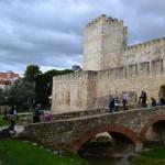
Meanwhile, we approached the center of Podgora, where the Trans-Volga St. Elias Church is located convent.
Trans-Volga St. Elias Convent, Podgory.
The village of Podgory owes its birth at the beginning of the 17th century to the Samara Spaso-Preobrazhensky Convent. The monastery built here a wooden church of Elijah the Prophet with a large tower. Over time, pilgrims began to settle around the church. At that time, the settlement was called Ilyinsky.

In 1865, at the expense of pilgrims, a stone church was built instead of a wooden one, which was partially destroyed during Soviet times. In our time, the temple was restored and by 2006, the Trans-Volga St. Elias Convent was founded at the church.

Restoration work in the temple and improvement of the territory of the monastery are still underway.

Next to the Church of Elijah the Prophet, a wooden church was built in the name of the Holy Martyr Constantine


and the Chapel of the “Life-Giving Spring” of the icon of the Mother of God.


Nearby are the cells of the nuns. A very nice place.

During a conversation with one of the nuns, they gleaned information that the monastery accepts pilgrims for lodging and does not take money for overnight stays for help with housekeeping, but also provides food. A large pilgrimage center was built for these purposes.

Behind the main church of the monastery there is a small necropolis, in the middle of which is the grave of the first abbess of the monastery, Anastasia Shestun. The Church of Anastasia the Pattern Maker, built in honor of the abbess, did not survive our arrival; it recently burned down.

There is a nice fountain built into the wall, in which it is strictly forbidden to wash your hands (sign below).

Opposite the entrance to the monastery there are surprisingly new houses. I wonder who lives in them?

We were in the nunnery, now it’s time to go to the men’s monastery. You should definitely visit the monastery. If only because there is a holy spring on its territory where you can swim.
Trans-Volga Monastery in honor of the Life-Giving Cross of the Lord, Podgora.
From women's to men's the walk is about two kilometers. We walk in the direction from the Volga perpendicular to Cavalier of Glory Street. The monastery is not located in the village itself, but on the territory of the Samarskaya Luka nature reserve, and first you need to leave Podgory.
Map of Podgora.
A few more photos of the village of Podgory.


We go out onto Lesnaya Street, along which we came to Podgory. Lesnaya is eastern border sat down.

At the foot of Mount Plaxikha (the mountain got its name because high level groundwater) there is a checkpoint to the territory of Samarskaya Luka, this is evidenced by a large number of posters.


Near Mount Plaksikha is Mount Manchikha, named so, according to legend, in honor of the chieftain Mani Chikha.

Entrance to the reserve is paid - a ticket costs 50 rubles per person, but we were lucky. We didn’t meet anyone at the checkpoint, probably everyone had gone to lunch.

The road to the monastery is dirt and very beautiful.


In the opposite direction, Samara is visible on the horizon.


Unnoticed we find ourselves at the gates of the monastery.


Source of St. Elijah and Zavolzhsky Monastery, Podgory.
The monastery began to be rebuilt in 2006 at the source of St. Elijah. First of all, the wooden Church of the Life-Giving Cross of the Lord was built.


The source itself was abandoned until 2003. It was cleaned, ennobled, and a bathhouse was made next to the source. Swimming in clean, spring water, oh, how nice!


With new strength we set off on the way back to the Podgora pier. The pier is located two kilometers from the village, and four kilometers from the source.
Photo of the village of Podgory and its surroundings.


I have already written about these most beautiful places where I had a chance to spend my vacation last summer. Much did not fit into the last post, well, you cannot cover and convey everything, and much of what was planned was simply not possible to visit. And so, having decided to make up for lost time, we again went for a walk in these picturesque places. Walk through the sprawling carpet of herbs of flowering meadows, breathe in the heady aroma of herbs in the air, and drink delicious water from the spring. In general, return, at least for a short time, to these fabulously beautiful places.

This time we took a river bus to the Podgora pier and, after passing through a series of tourist centers located on the coast, we reached the road to the village. I still don’t understand, by the way, whether this is one tourist center, or some kind of metropolis formed by the merger of several smoothly flowing into one another, as hinted at by the differences in the architecture of the panel houses. To be honest, these wonderful cubbyholes reminiscent of my uncle’s pumpkin house always make me smile and misunderstand. Well, in a tent, in my opinion, it’s much more comfortable. The taste and color, as they say... And we hastened to quickly pass this boiling cauldron of the holiday torment. And now, already a hundred meters from places of public recreation, nothing reminds you of the bustle, you begin to simply enjoy the nature around you, the singing of birds, falling into a kind of relaxation.

We visited in the second half of June, at which time the strawberries were ripe. But she is apparently not visible here. The berries, sweet in taste with a slight sourness, grow here in whole clearings, here and there we meet along the way. Literally under every leaf hides a whole scattering of these delicious berries. But picking them is not so easy; not only are the berries themselves not large and picking them is painstaking work, but they are also under the watchful eye of an army of mosquitoes. So an acupuncture session during collection is guaranteed.
On one of the lakes I noticed how ducks, disturbed by someone, took off and took pictures; unfortunately, I didn’t have time to photograph them.
But he filmed other birds. Unfortunately, I don’t know their names.

By that time, the morning cool had completely dissipated, the sun began to get hot, warming up the meadow, which began to exude bouquets of aromas. It was getting really hot. The bottle of water was quickly emptying, risking running out before we reached the village. Soon a thin veil fell over the sky, partly providing relief from the already scorching sun. Mount Belaya appeared. Yes, we planned to climb onto it this time and even look inside, but I won’t get ahead of ourselves, more on that later.

And on the other side, the Trans-Volga St. Elias Convent appeared. I really like the view of the monastery complex from here. When it is no longer far away, the details are easily distinguishable, but also not so close as to obscure the surrounding landscape, but harmonizes with it and even fills it. Coming closer, these sensations are already lost, he ceases to be part of the surroundings, and becomes the center of attention.

The roads here are real, the ones about which songs are written, seven bends per mile. They wind and wind like a snake among meadows, lakes, woodlands, beauty. And why is it straight, so that you can pass quickly, slip through, without noticing all this beauty? And she meanders and circles, saying, look around, look around again, don’t leave, admire.

I won’t try to convince you that the places here are truly fabulous. Anyone who wants can come and see for themselves. And anyone who believes in the unusualness of these places will definitely find something special. We had just entered the village when we met Pull-Push on the way. Dispute away, is it an antelope or a horse with two heads. Pull-push is a goat, or a goat, at least that’s what the Samara specimen is like.

Just like last time, we didn’t really walk around the village and our acquaintance with the convent was also postponed for future trips. Having passed the village, we went to the source located on the territory monastery, it’s just a stone’s throw from here, just two kilometers.

Part of the path passed along the road, an ordinary asphalt road, heated by the sun and more reminiscent of a hot frying pan from which the heat rises. I like this part of the journey least of all, or rather, I don’t like it at all. It’s not great after the rain, or when you come across such a road, to walk on asphalt, and not through mud, which either sticks in lumps to the soles of your shoes, or turns into a slippery viscous substance trying to throw you off balance. But not now, a walk on the asphalt awakened thirst. The remaining water was only enough for each person to take a sip, after which she immediately came out later, and the desire to drink did not dull one bit. This fact aroused the desire to quickly get to the source. Having passed the checkpoint, we bought vouchers, such checkpoints were placed on all known routes, so that now it is officially on the territory national park Samara Luka you need to purchase a ticket. However, the amount is not significant, I hope this money will benefit the park.

Further the road was very picturesque. The presence of a large number of butterflies added to the unusualness. They were just fluttering around. Others in whole groups sat right on the road, squeezing moisture with their proboscis from the dry, but still wet places of the former puddles, taking off right in front of us, disturbed by our footsteps. Sometimes we had to step very carefully when passing such a group; the butterflies were not at all frightened by our presence. I have never seen so many of them. There was a feeling that we were approaching a very unusual place.
Suddenly the gates of the monastery appeared.

On the territory of the monastery there is a temple in honor of the erection of the Precious and Life-Giving Cross of the Lord. A beautiful temple made in the traditions of Russian wooden architecture. Its bulbous heads are covered with many carved wooden plates - ploughshares, carefully fitted to each other. This is rare to see these days.

In the center there is a large mosaic icon of Elijah the Prophet.

A spring with delicious cold water. And next to it there were two velos, my old little dream.
And again there are a lot of butterflies.


Having drunk plenty of spring water from the source and replenishing its reserves, we move on. The next planned point of the route was the ascent to White Mountain. It got its name from the white color of the limestones, the sedimentary deposits from which it consists in some places exposed. The mountain is not high, but climbing it on a hot summer day turns into a bit of a challenge. The trails are located on open, bald slopes, the soil here warms up nicely, creating a bathhouse effect. But the climb is worth it, from the height there is a magnificent view of the valley, the village, Stone Lake located at the foot and it seems to be a stone's throw from here to Samara.


In general, the mountain is fraught with a lot of interesting things; there was once a settlement of the early Iron Age (VIII-IV centuries BC) located on it. This type of settlement began to be called Belogorsk, after the name of the mountain, or the southern version of the settlement of the Ananino culture. Also, traces of settlements were found at the foot of the White Mountain; there is a version that during the period of the Volga Bulgaria, before its defeat by the troops of Batu Khan in 1236, there was a village under the mountain, whose inhabitants hid in a fortress on the White Mountain during the periods of the invasion of nomads.
But this is not the only thing that makes White Mountain special. To see the next attraction, we walk along the road towards the village of Gavrilova Polyana, turn onto a path barely noticeable among the grass and go up the mountain again.

This time the trail passes through the wooded part of the mountain, the climb is easy, especially when mosquitoes literally start nibbling on you, at first it’s even invigorating. Here they are apparently invisible, and the closer we get to the next point on the route, the more and more there are of them. But suddenly an unusual picture opens before your eyes and you, for a while, forget about everything.

A haze spreads across the ground, illuminated by the sun's rays, it looks simply fantastic. And then, in order not to completely lose the sense of the reality of what is happening, the same little annoying creatures come to your “help”, constantly biting you, trying to drink every drop. They shook them off almost by the handful. A couple more steps and we were on small area in front of the Ice Cave. Another name for the Gnilaya cave (Gnilaya cave), but due to the constant presence of ice in it, it is often called the Ice Cave; I prefer this name. After thirty-something degrees, even next to the cave it is quite cool. And the cold air coming out of it is the reason for the origin of the creeping haze that impressed us so much.

There is snow at the entrance to the cave, and this despite the fact that June has already passed the middle, and the heat outside is thirty degrees. Before entering, I put on the jacket I took with me specially and go inside. The cave is cold, the temperature is negative and it is constantly draughty. The cave lives up to its name and there are ice formations and icicles on the cave walls. The constant flow of cold air is associated with the presence of karst cavities in the interior of the mountain and the porosity of the gypsum itself. Just imagine average speed the air flow is approximately 3 m/s, which gives an air flow of approximately 6 m3/s. The negative temperature in the Ice Cave persists even in August.


The ice cave is not deep, the entrance is quite spacious and at the entrance there is a small hall with a ceiling tapering into the depths. The hall ends with two passages, one of which is more like a hole with a low ceiling; you can only move in it by crawling, and the floor is covered with a layer of ice. I didn’t have a flashlight with me, and I couldn’t see how deep it was. The second passage narrows into the depths of the cave with smooth, as if polished corners of the stones. I tried to climb, but it was inconvenient to climb with a tripod and a camera; getting stuck halfway up, I backed away.


Having rested a little from the heat and even managed to freeze, we leave the cave and move on.

Along the mountain stretches a branch of Stone Lake from the village of Gavrilova Polyana, where it connects with the Volga with a small riffle and to the village of Podgory. And between the White Mountain and Stone Lake lies the road, the same asphalt one along which we had to walk a few more kilometers.
And this is a view of that same Stone Lake.


We take a short break in a picturesque place, on a small cape cutting into the lake, sitting on a thick grass carpet. We chose this cape last year when we came here. Fortunately, the place is not very popular among vacationers and tourists because it is quite clean, I noticed only one place of a former fire pit and there is no garbage.


And these are the willows in Gavrilova Polyana, mighty trees, even two people can’t cover this. There used to be a lot of them from the pier towards Shiryaevo, but now there are almost none left. But they still stand on the right side of the pier.


Here at the pier our little hike ended.

Having settled down on the grass, we whiled away the remaining hour until the river bus arrived. My legs were pleasantly buzzing from fatigue, this humming in my legs was pleasant because the route had been completed, a small overcoming with a lot of positive emotions and impressions.

And Samara greeted us with a beautiful sunset sky.
See more about these wonderful places.
Here is a detailed map of Podgora with street names in Russian and house numbers. You can easily get directions by moving the map in all directions with the mouse or clicking on the arrows in the upper left corner. You can change the scale using the scale with the “+” and “-” icons located on the map on the right. The easiest way to adjust the image size is by rotating the mouse wheel.
In what country is the city of Podgora located?
Podgora is located in Croatia. This is wonderful beautiful city, with its own history and traditions. Podgora coordinates: north latitude and east longitude (show on large map).
Virtual walk
Interactive map Podgora with landmarks and other tourist sites is an indispensable assistant in independent travel. For example, in the "Map" mode, the icon of which is in the upper left corner, you can see the city plan, as well as detailed map highways with route numbers. You can also see the city's railway stations and airports marked on the map. Nearby you see the “Satellite” button. By turning on satellite mode, you will examine the terrain, and by enlarging the image, you will be able to study the city in great detail (thanks to satellite maps from Google Maps).
Move the “little man” from the lower right corner of the map to any street in the city, and you can take a virtual walk around Podgora. Adjust the direction of movement using the arrows that appear in the center of the screen. By turning the mouse wheel, you can zoom in or out of the image.