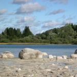
Mount Stolovaya (2993 m)
Table Mountain is one of the largest in the Rocky Range. It is located south of the city of Vladikavkaz and is clearly visible from almost any area. The distance to it from the city is about 15 kilometers. In clear weather, the entire massif, stretching from west to east, clearly appears. The mountain is the eastern (extreme) one in the Rocky Range on the territory of North Ossetia. Geographically it belongs to the Tseylam ridge (Ingush Republic). From the east it is limited by a deep depression - the Ger-chech pass, in the west - by the Baltic Gorge, through which the Terek River flows. To the south of it lies the valley of the Armkhi River (Ingush Republic).
The massif has two distinct peaks, between which rise several large gendarmes. The eastern peak (2993 m) is the main one. It looks like a huge flat table covered with grass. It was she who gave the mountain its name - Dining Room. From the main peak, a long ridge extends in a smooth arc to the northwest, falling steeply into the valley of the Terek River. It is called "Lion's Mane". To the south of it stretches the Vagai-choch gorge. Steep walls fall here
peaks dissected by narrow couloirs. Steep ridges descend to the north, covered in the upper part with grass, and below - overgrown with dense forest and shrubs. The western peak (2703 m) is separated from the main peak by a deep narrow bridge. It looks like a large cone with rocky ribs that fall evenly in all directions. It is called the “Head” of the Dining Room.
Ossetians call the mountain Dining Room Madhokh (Mother Mountain), and the Ingush call it Mat Lam, which has the same translation. On the eastern ridge, not far from the main peak, there is ancient sanctuary. There is a curious legend associated with this mountain. A long time ago, when cyclopes still lived in caves and dense forests, one of these monsters came to the kingdom located north of the present Table Mountain, conquered it and imposed a tribute: every year on the same day the most beautiful seventeen-year-old girl was to be brought to him . At the same hour, the monster appeared and, not paying attention to the heartbreaking cries of the residents, carried away the girl to then eat her. This went on for many years. But now the people discovered the secret of the monster: if the most beautiful girl will sacrifice herself, run out to meet him and throw herself into the mouth, the monster will die, and the people will be freed from a humiliating and heavy tribute. That year the beautiful princess turned seventeen. From early childhood, her father kept her locked up, fearing that she might become a victim of the bloodthirsty Cyclops. No matter how much the father hid the truth from his daughter, she still learned about the monster and the misfortune that befell the people, and that she was the most beautiful of her peers in their kingdom. The fateful day has arrived. Sobbing crowds walked to the plain to hand over the monster's next victim. And among them was hiding the princess, who had secretly escaped from the castle. When the monster approached the people, a princess of indescribable beauty broke out of the crowd and threw herself into its mouth. There was a terrible roar, a flame broke out, and everything was covered in smoke. When the smoke cleared, a mountain appeared before the astonished people - a beautiful princess lying on her deathbed. At this time, the princess’s lover, a brave young shepherd named Kazbek, was tending sheep high in the mountains. Hearing the noise, he looked down from the top and saw how the princess threw herself into the monster’s mouth. Unable to bear the death of his beloved, he rushed down the cliff, managing to shout that it would be better for him to turn into a mountain. And immediately the young shepherd turned into a two-humped mountain, rising high above all the mountains to guard the peace of his beloved.
What was the basis for such a legend? Most likely - the outline of a mountain. Looking closely at the contours of the mountain (it is more convenient to observe from the northern part of the city in clear weather, immediately after sunset), you can see a head with loose braids, fairly clear outlines of the face, chest, abdomen, and legs. On the coat of arms of the city of Vladikavkaz, created in 1873, the silhouette of Mount Stolovaya is one of the components.
A number of routes lead to the top of the mountain. Some of them are popular. Mass ascents were made along them repeatedly, usually dedicated to some kind of anniversary. The dining area is replete with numerous grottoes and caves. One of them - Stalactite - is located in the northern spurs of the mountain.
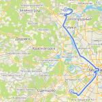
Route 6 to stalactite cave(diagram 2, compiled based on materials from S. F. Grigorovich, 1960)
The path from Vladikavkaz along the VGD after 11 kilometers leads to a lime plant (located near the road, now abandoned). Then the movement goes south 150 meters to the suspension bridge over the Terek. Behind the bridge begins a path that leads east along the Terek floodplain. From the coastal terrace, where the path leads, the houses and gardens of the village are clearly visible. Chernorechensky. You can get there by regular bus from Vladikavkaz.
Crossing the village, climbing to the eastern bank of a deep rocky gully, the path, following east, leads to the forest. At the edge of the forest lies a second shallow ravine, overgrown with bushes. By west bank Beams to the south there is a road that turns east and enters the forest. There is a descent to a small river. The road continues along the left bank, then crosses to the right bank, leaves the river, passes through a young forest, heading southeast. Soon the forest parts and a beautiful clearing appears. The rugged peaks of Table Mountain jut out ahead to the south. From here you can clearly see the gorge separating the peaks of the mountain.
The forest road goes south. The movement continues along a wide path that looks like a forest clearing. The trail gradually deviates to the south and leads to a small stream. Behind the stream there is an exit to a clearing. Among the young forest on the southeastern edge of the clearing stands a tall beech with a forked trunk. It is advisable to arrange here a little rest, stock up on water. To the right of the beech tree, 50 meters away in a gully there is a spring.
The path goes east. The forest is changing. Old beeches rise high. The mountain slopes are cut by deep gullies. Piles of yellow leaves and fallen trees are visible everywhere.
After 1.5 kilometers, after crossing the ravine, you turn south to a wide clearing visible on the mountainside. The cave is close, only 500 meters away, but the climb to it is steep. The clearing was overgrown with ferns and weeds almost as tall as a man. Thick layers of limestone are visible on both sides. The clearing is surrounded by old maples and linden trees. East End The clearing abuts a rocky ledge. At its foot you can see the entrance to the cave.
From the village Chernorechensky to the cave is a 3-hour walk.
The length of the cave is 34 meters, width is 25 meters, and height is more than 10 meters. This is a wonderful creation of nature. Lime streaks-stalactites hang like icicles from the ceiling of the cave, and columns of stalagmites rise from the bottom. The cave is cold and dark. In the light of lanterns and candles, stalactites and stalagmites take on fantastic shapes.
Travel time with return to Vladikavkaz takes 8-9 hours.
Route 7 to the village of Beini from Vladikavkaz(scheme 2)
The village of Beini is located in the gorge of the river. Armhi. From Vladikavkaz to the river gorge. Armkhi along the IOP is 23 kilometers.
The path starts from the former camp site, located on the corner of General I. A. Pliev Street and Costa Avenue. The highway passes between the slender pines of the forest park, in which there are rest houses and gardening farms of the townspeople. At the intersection with the bypass road, it goes up from the motel cable car, leading to the top of Bald Mountain (now not working). Behind the traffic police post the Georgian Military Road begins. The steep slopes of the surrounding mountains are covered with dense forest. Below stretches the wide floodplain of the Terek, into which the spurs of the Limestone Mountain fall.
After 20 minutes, at the fork on the village. Redant shows a small abandoned lime factory. Above it rise steep cliffs, mastered by climbers and climbers who conduct training and competitions here.
On the right bank of the Terek, the Table Mountain massif opens wide. Can be seen from the village. Balta, that its peaks surprisingly resemble the famous Ushba in miniature.
Leaving the developments of Kavdolomit on the left, passing the villages of Balta and Chmi, turning left, the road crosses the bridge over the Terek, leading to the Ezmin hydroelectric station. Here it splits into two. A narrow dirt road turns left into a small gorge leading to the Table Mountain massif. A wide road covered with gravel leads to the beginning of the Dzheirakh gorge. Before the bridge over wild river Armkhi erected a monument to the revolutionary hero Ingush Akhriev. From Vladikavkaz to the fork it is 21 kilometers.
The altitude mark is 920 meters. Nature changes dramatically and becomes steppe. The sharp contrast in the appearance of the slopes of the Skalisty and Bokovoye ridges is striking. In this place, the first, constantly dried by the rays of the sun, is covered with steppe vegetation. Thorn bushes - astragalus - are visible everywhere on the slopes. On Bokovoe, facing north, a dense forest grows and noisy streams run. The road rises steeply above the Armkhi River, leading to the village. Dzheyrakh. (Ingush Republic). Passing the village, the road descends into the river valley. Armhi along the layers of destroyed shale.
The valley of the Armkhi River, the largest tributary of the upper Terek, stretches between two ridges: Skalisty and Bokovy from west to east. Because of this location there is a lot of sun. The village of Beini is located on the opposite slope at an altitude of 1540 meters above sea level. On the outskirts, a dilapidated tower has been preserved. On the slopes of the surrounding mountains you can see the remains of Ingush villages.
K s. You can also drive from Beini village. Furtog along the right terrace of the Armkhi River - 10 kilometers from the VGD. Before climbing to the top of Table Mountain, you should spend the night near the village; there is water.
Route 8 to Mount Stolovaya from the south of the village of Beini(diagram 2, 4; photo 2)
The ascent begins early in the morning. The ascent follows a path leading to the saddle of the ridge. You need to stock up on water at the spring. From the saddle, the movement continues along fragrant meadows dotted with mountain flowers in early summer to the northwest, and then to the north, focusing on the table-top of the mountain visible ahead. Along the way, the karst forms of the mountain attract attention: grottoes, gullies. Passing the ancient sanctuary, there is an ascent to the summit table. The path follows the table's meadows to its western raised edge, which is the summit. Here the tour is made of stones. From the saddle to the top it is 5 kilometers. The air at the top is clean and fresh, the bright rays of the sun are scorching. The buildings of the city of Vladikavkaz and the villages scattered across the plain are clearly visible, from here they seem like toys. Kazbek rises in the south. From it to the west and east, the mountains of the Side Range stretch in an endless ridge. In clear weather, the blue peak of Elbrus can be seen in the distance. Here, at an altitude of 3000 meters, there is an unusual silence.
The descent follows the ascent path or Route 13.
Climbing with return to the village. Baney takes up the full daylight hours. The route is long, but technically not difficult. Climbing participants are required to have average physical fitness and basic skills in moving in the mountains. It is necessary to have tourist clothing, food supply for two days, and bivouac equipment.
Route 9 to Mount Stolovaya along the southern ridge from the Akhriev Estate Museum(scheme 2, 4; Fig. 1; photo 2)
The access from Vladikavkaz to the fork in the road at the Ezminskaya hydroelectric station is described in Route 7.
From the fork, move left along the dirt road into the gorge leading to the Table Mountain massif from the west. After 1 hour of walking, at the end of the gorge, the road turns right up and leads to the Akhriev Estate Museum, located on a wide grassy southwestern ridge. From here you can see both peaks of Table Mountain with two large gendarmes between them. The path goes up along a wide, steep rise of the ridge, overgrown with sparse forest, gradually taking a southern direction. Above the middle part the ridge flattens out and the forest ends. It is advisable to make a rest stop here. The top table is nearby. A steep grassy slope leads to a rocky ridge. Climb along the easy rocks of the ridge to the summit table. The rocks are replete with niches and grottoes. To the west the table ends with sheer rock walls. Move along wide meadows with gentle slopes to the top.
From the museum-estate 4-5 hours.
Descent along the ascent path.
The route along the southern ridge is steep, but not technically difficult. It requires participants to have good physical fitness, basic skills in moving in the mountains, hiking clothing, food and drink. In summer there is no water on the route; in the off-season and in winter there is snow. You can extend the route by descending from the summit north to the VGD along Route 13-10.
Route 10 in the Vagaychoch Gorge (Bear Gorge)(diagram 2, 4; photo 3)
The picturesque Vagaychoch gorge stretches between the “Lion’s Mane” in the north and the western ridge of the “Head” of the Dining Room in the south. Formed where rocks were bent as a result of a tectonic fracture.
The entrance to the gorge starts from the 16th kilometer of the VOP. Having passed the bridge over the Terek, the Kavdolomite building, the road, covered with white dolomite dust, rises in steep zigzags into the gorge. In its middle part it flattens out. The gorge is narrowing. On the edge big quarry there are workers' houses. At the end of the 70s, there was a large clearing through which a stream with clean water flowed. It was a traditional gathering place and resting place for participants climbing to the top. Further the trail goes through a dense low forest overgrown with bushes. There is no visibility, only the steep sides of the gorge rise above. Gradually the forest thins out, the gorge narrows, turning into a canyon. A small cave is visible in the steep cliff above. Cool and gloomy. More and more often there are stones and boulders on the path and, finally, it becomes completely rocky. The gorge ends with a fork under high rocks. A narrow, steep gorge goes to the right, leading to a small bridge between the gendarme and the “Head” of the Dining Hall. On the left stretches the northwestern ridge “Lion's Mane”.
The length of the Vagaychoch gorge is 10-12 kilometers, about 3 hours of walking.
Route 11 to Lion's Mane from the south
Exit to central part Lion's Mane follows a path that climbs steeply up a grassy slope. There are a lot of “live” stones on the trail; when it rains, it becomes slippery. When climbing, you should make frequent rest stops. The ridge is overgrown with frequent dwarf birches. The path goes up smoothly. The forest parts and opens up ahead Northern part a massif with steep rock walls cut through by narrow couloirs. In a wide depression of the ridge in front of the rocks comfortable spot for bivouac and recreation. There is no water, there is snow in the off-season and in winter.
From the fork about 3 hours.
The route requires participants to have good physical fitness, hiking clothing, food and drink. With the return to IOP, it takes a full day of light.
Route 12 to Lion's Mane from the north(diagram 2; Fig. 2; photo 3, description based on materials from B. M. Beroev)
Access to the village Terk from Vladikavkaz by car takes 30 minutes. From the right bank terrace of the Terek near the extreme southern houses of the village. Terk should enter the forest. Near a small river, turn south and move along its left bank along a forest dirt road, which gradually turns into a path. The first 1-1.5 kilometers the climb is insignificant. Then the trail begins to climb steeply through the plane tree forest, with slight zigzags in places. After 1.5 hours of driving through the forest, you come to a small crossing, from which you ascend through the forest along a slope to the “Lion’s Mane”. After another 1.5 kilometers, the forest ends, and then there are animal trails, laid in the raspberry thickets up to the ridge.
The descent follows the ascent route, or, going down along the ridge for 1.5 kilometers, parallel to the ascent route. It is possible to descend into the Vagaychoch gorge along the Route. eleven.
The length of the route is 14-15 kilometers, duration is 6-7 hours.
Route 13 to Table Mountain from the north (1B)(scheme 2, 4; Fig. 2; photo 3)
The ascent to the Lion's Mane is described in Routes 10-12.
From a wide depression in the ridge in front of the rocks, move up along simple rocks or around them. The steepness of the ridge reaches 40-45 degrees. After 2.5 hours, approach under a steep (up to 55°) wide couloir, about 60 meters long. Here you need insurance and hanging railings. In the off-season and in winter there is snow in the couloir, and ice is possible in the upper part. There are steep cliffs around.
The couloir brings the tops to the table. The summit tour is made of stones 100 meters from the edge of the table.
The route from VGD to the top takes 6-7 hours. Requires participants to have the skills to move in the mountains, travel clothing and equipment (ice axes, rope), food and drink, and bivouac equipment.
Route 14 to Table Mountain from the west (2 ks)(Scheme 4; Fig. 2; Photo 3)
On April 20-21, 1991, a group of climbers from North Ossetia tried to climb the route from the side of the “Head” of Stolovaya, passing the last traverse from the south and descending to the col in front of the 1st gendarme. Group members: Yu. V. Levkovsky, I. O. Afanasyev, I. O. Bondarenko, A. P. Glazov. A rough description is given.
The approach along the Vagaychoch gorge to the fork is described in Route 10. Turning right, climb along the left side of a narrow steep gorge, above the middle part turning into a couloir. In the off-season there is snow and the slopes are saturated with water. The couloir is clearly visible from Vladikavkaz. After 2-3 hours we reach a small bridge between the eastern ridge of the “Head” of the Stolovaya and the 1st gendarme. To the south the lintel ends with steep walls. To the left and up in the ridge leading to the main peak, there are rocks of the “mutton’s forehead” type, about 2-3 k.f., in some places perhaps 4 k.f. Hook belay and railings are required. The length of the rocks is about 100 meters, the steepness is 45-50 degrees. The rocks lead out onto a wide, steep scree shelf that goes around the 1st gendarme on the left. The length of the shelf is 150 meters. The regiment leads to the western ridge behind the 1st gendarme. Then follow the easy western ridge through the 2nd gendarme to the rocks of the western side of the summit table. Along one of the short steep couloirs you reach the summit.
The duration of the route is 2 days with an overnight stay on the western ridge or at the top. Equipment - ice axes, ropes, rock pitons.
Route 15 to the “Head” of Dining along the eastern ridge (1A)(Scheme 4: Fig. 2; Photo 3).
The ascent to the col between the eastern ridge of the “Head” of the Dining Room and the 1st Gendarme is described in Route 14.
40-60 meters from the lintel, turn right and emerge onto a narrow, steep grassy and rocky shelf 40 meters long. Further movement along a steep grassy slope with access to the eastern ridge. First, 20-30 meters along the simple rocks of the eastern non-steep ridge, then 150-200 meters along a large scree with large boulders to a large gendarme, which you can go around on the right along a steep grassy slope (in the off-season and in winter there is snow, increased avalanche danger,
key section of the route, belaying with an ice axe, hanging handrails possible). Follow the ridge after 100 meters to the top.
From the fork at the end of the Vagaychoch gorge it takes 5-6 hours.
The route requires climbing participants to have knowledge and skills of basic mountaineering training. You must have ice axes and rope.
Route 16, to the “Head” Dining Hall from the south (1B), option 1(scheme 4)
The path to the fork in the road at the Ezminskaya hydroelectric power station is described in Route 7.
From the fork, turn left along the dirt road into the gorge leading to the Table Mountain massif from the west. After 1 hour of walking, at the end of the gorge the road turns right up and leads to the Akhriev Estate Museum, located on a wide grassy southwestern ridge.
The route continues along the gorge, which narrows, turning into a canyon with steep rocky and grassy slopes. After 1 hour there is an approach to a rocky step blocking the gorge. An eight-meter metal ladder hangs from above. Climb the stairs and again move along the bottom of the gorge. Gradually the gorge widens, the slopes lose their height and become flatter. The gorge turns into a large gully. The rock mass of Table Mountain opens ahead. To the left, steep grassy slopes lead to the southern ridge of the “Head” of the Dining Room.
The duration of the route from the road fork at the Ezminskaya hydroelectric station is 4-5 hours.
Route 17, to the “Head” Dining Hall from the south (1B), option 2(scheme 4)
At the end of the gorge, from the turn of the road to the Akhriev museum-estate, turn left and climb 250-300 meters along a steep shallow scree under the rocks. Here you need to find the beginning of the path, which goes among the rocks on the right side of the gorge. The first approach to the route passes along the bottom of this gorge. Winding among the rocks, gradually gaining altitude, the trail leads under the grassy slopes of the eastern side of the southern ridge of the “Head” of the Dining Room. Climb along steep (up to 45 degrees) grassy slopes to the southern ridge. On the left you can see a large flat peak on which the repeater stands. This is Mount Dikdu (2196 m). From the saddle of the southern ridge good view in all directions. A panorama of the Table Mountain massif opens.
The routes take place during full daylight hours. Both approach options require participants to have average physical fitness, basic mountain mobility skills, hiking clothing, food and drink. There is some difficulty in climbing the metal ladder into the gorge, as well as the steep grassy slopes when reaching the southern ridge.
Route 18, to the "Head" Dining Room from the south (1A)(Scheme 4; Fig. 1; Photo 3)
The path to the top goes along a wide southern ridge overgrown with grass, leading to the beginning of a talus couloir. Climb along the steep scree of the couloir, then along its right side under the rocks. In the middle part of the couloir, turn right and move along a narrow, steep rocky and grassy shelf 50 meters long, at the end of which there is an unpleasant psychological section with a protruding rock. Further left up a steep (up to 50 degrees) grassy chute to the ridge. On simple rocks 1-2 k. climb to the top.
From the fork in the road at the Ezminskaya hydroelectric station it is 7-8 hours.
The route requires that participants in the ascent have knowledge and skills of basic mountaineering training. You must have ice axes and rope. There is no water on the route.
From the west, a rocky couloir leads to the top of the “Head” of the Stolovaya. Passed by R.P. Proskuryakov and rated as 2A class.
Table Mountain (Vladikavkaz, Russia) - detailed description, location, reviews, photos and videos.
- Last minute tours in Russia
Previous photo Next photo
Table Mountain is depicted on the coat of arms of Vladikavkaz and is clearly visible from the city. It is also present on the coat of arms of the Republic of Ingushetia, as it stands on its border with North Ossetia-Alania. This is one of the largest peaks of the Rocky Range of the Caucasus Mountains, its height is about 3000 m.
Table mountains or tabletop mountains are considered the oldest geological formations. Their feature is a flat top and steep slopes; this shape really resembles a table.
The Caucasian Table Mountain has always been revered local residents, it was an analogue of the Greek Olympus, that is, it was considered the residence of the gods. The ruins of many sanctuaries, mainly from the 10th to 18th centuries, have been preserved on the mountain. The oldest of them, Myat-Seli, dates back to the 4th-8th centuries.
There are hiking trails on the mountain, climbing which takes several hours, but does not require special physical training or equipment. The most convenient of them starts from Ingushetia and is called the “path of ancestors”; mass ascents of up to 300 people are organized along it simultaneously.
Practical information
Address: Republic of North Ossetia - Alania, Prigorodny district. GPS coordinates: 42.868331; 44.703331.
The most convenient way to get to Table Mountain is by car; the road from Vladikavkaz will take about 40 minutes. You need to drive along the A-161 highway (Georgian Military Road), then turn onto P-109 and move to the village of Beini, where the road ends.
Along the way there will be several checkpoints where they only check Russian passport.
On the border with Ingushetia and North Ossetia there is a landmark unique in its beauty and unusualness -. located not only on the coat of arms of this beautiful city, but so is the same on the coat of arms of the Republic of Ingushetia. Such great attention and great love for ancient education is marked by the truly special uniqueness of this attraction.
The vertical steep slopes of the mountain and the flat top resemble a table, which is why all formations of this kind are usually called Table Mountains.
A unique miracle of nature
How high is the Vladikavkaz table mountain and how to get to it
Height of Table Mountain is 3003 m. Therefore, it is visible from a large number of places North Caucasus and is one of the largest peaks of the mountain range. But such a height did not become an obstacle for a large number of tourists flocking here from all over the planet.
Climbing the Vladikavkaz table mountain Quite a simple journey. There is an easy trail from Ingushetia. It is not at all difficult and does not require any special mountaineering skills. The mountain itself can be reached by car. The journey from the city of Vladikavkaz will not take much time. In 40 minutes you will pass several checkpoints where only your Russian passport is checked, and you will find yourself at the foot of the mountain. The route runs along the A-161 highway, which has another name: the Georgian Military Road.
Afterwards you need to turn onto the P-109 highway and drive to the village of Beini, where the road ends and begins walking route. After leaving this village you will see the beautiful Beini Towers. After the towers, turn right and you will find yourself on the hiking route. And then everything happens in an elementary way. You simply follow the path without turning anywhere.
Snowy peaks of the CaucasusLegends of the origin of the mountain
There are an endless number of legends about the origin of this mountain, each of which is interesting in its own way. But the most basic legend of table mountain Vladikavkaz talks about a young beauty and a young man in love.
In ancient times, a certain people lived in this place who were conquered by a dragon. Every year this beast took tribute from the population in the form of a young girl and took her to his cave. It was possible to get rid of him only if the young lady herself decided to jump into his mouth.
Meanwhile, the prince grew up with a beautiful daughter, whom he protected throughout her life. When she turned 16, the prince locked her in a tower to protect her from the dragon. But the girl escaped, disguised as a maid. She decided to save the village and jumped into the dragon’s mouth herself. The dragon caught fire and turned to ash. As a result of such miracles, a mountain was formed, on which the dead girl remained lying. Meanwhile, in the mountains, the shepherd Kazbek was tending sheep. He was secretly in love with this girl. And he asked the gods to turn him into a mountain too. He ran and quickly jumped down. At the site of his death, a mountain was formed, which was named Kazbek. That's how they stand to this day. beautiful mountain Kazbek and the young and feminine Table Mountain Vladikavkaz, delighting us and inspiring us to unusual feats.
North Ossetia is a region famous for its beautiful majestic mountains. No wonder they are considered the adornment of the republic.
It is not at all surprising that over time the flow of tourists eager to conquer unattainable peaks and admire the picturesque region from a bird's eye view does not dry out. Alanya attracts those who cannot imagine their holiday without mountains.
Mountain ranges of Ossetia
Ossetia is surrounded on both sides mountain ranges Central Caucasus, the different heights of which create fascinating multi-level transitions. The Lesisty ridge rises to just 1300 m. It received this name for a reason; its entire surface is hidden by dense vegetation; nature did not skimp on bestowing such a luxurious “gift” on the ridge.
Next to the Lesisty ridge, two more ridges rise: Pastbishchny and Skalisty. The rocky ridge, just by its name, is ready to tell tourists about its distinctive features. Everything about it is beautiful: steep slopes and unique gorges.
It is impossible to remain indifferent at the sight of high massifs, the peaks of which rise more than 3000 m above sea level:
- Table Mountain of Ossetia;
- Kion-hoh;
- Kariu-hoh;
- Tbau-hoh;
- Urs-hoh;
- Oise-hokh.
You cannot ignore the ridge called Bokovoy. Its peaks fascinate with the desire to reach the heavens themselves; their height is slightly less than 5000 meters.
It is impossible to visit this amazing republic and not visit the Watershed Range, the peaks of which seem unattainable. Our travel club will help you choose exciting adventure tours for lovers active rest with visiting all these amazing places.
Mount Lysaya
The smallest in height is the ridge of the Greater Caucasus - Bald Mountain, whose height is only 1038 m. The mountain delights with its amazing combination of forest, covering almost the entire surface with dense green natural plantings, and a completely bald top, which gave the name to the mountain.
There is an observation deck at the top of Bald Mountain. Some tourists climb it on foot. The path is not close, you have to cover 4 km, all the while going up. Having reached the top, you can enjoy the beauty of the local surroundings: settlements, fields, and the rapid Terek. Here you can have a great rest, visit a cafe whose menu is replete with Caucasian cuisine.
What can you see in North Ossetia when going to Bald Mountain?
In North Ossetia, Bald Mountain is located on the lowest Wooded Ridge of the North Caucasus. Its height is just over one kilometer.
Geographically, it is located on the very outskirts of Vladikavkaz, which is visited by every tourist heading on vacation to North Ossetia.
The entire foothills of this peak are covered with forest; the very top of the mountain remains bare. This is why it got its name. During Soviet times, this area developed rapidly. A new tourism infrastructure was created here. In the 1970s, a cable car was built here, which was very popular among tourists coming to North Ossetia. Bald Mountain had an observation deck that could be reached by cable car. After the collapse of the USSR, the cable car was closed. It’s not open yet, but walking up to the Bald Mountain observation deck is no less interesting and exciting. A large number of tourists today with their families carry out such a climb.
Walk to observation deck only 4 km. From the top of the mountain there is an unforgettable view of the Ossetian Valley and the spurs of the Caucasus Range. You can also get here by car along a special route laid in the southern part of the mountain.
Table Mountain North Ossetia
The two republics of Ingushetia and North Ossetia are separated by Table Mountain. She is loved local population, so it is not at all surprising that the coat of arms of Vladikavkaz is accompanied by her image.
In addition to Table Mountain, North Ossetia offers its guests many interesting routes. The famous Georgian Military Road, which leads to Tbilisi. Its length is 207 km. This ancient path has been known since ancient times. Today tourists can walk it or drive by car.
Lovers of relaxation in comfortable conditions can visit famous resorts North Ossetia:
- Tamsik.
Vacationers here are offered not only treatment mineral waters and miraculous mountain air. From here you can organize excursions to the famous " City of dead", located in the suburbs of the village of Dargvas. In North Ossetia there are many ancient monuments that date back to the Bronze and Iron Ages. One of them is located in the mountain village of Koban. In the 19th century, burial grounds with unique household items and decorations were found here.
Tourists traveling to North Ossetia will be able to see many interesting things during their trip. To do this, you need to choose a suitable route in a timely manner. Travel club Otkritie is ready to assist in organizing active recreation tours with various types traveling around North Ossetia.
To the Table Mountain from the south
The ascent begins early in the morning. The ascent follows a path leading to the saddle of the ridge. You need to stock up on water at the spring.
From the saddle, the movement continues along fragrant meadows dotted with mountain flowers in early summer to the northwest, and then to the north, focusing on the view ahead mountain top table. Along the way, the karst forms of the mountain attract attention: grottoes, gullies.
Passing the ancient sanctuary, there is an ascent to the summit table. The path follows the table's meadows to its western raised edge, which is the summit. Here the tour is made of stones. From the saddle to the top it is 5 kilometers. The air at the top is clean and fresh, the bright rays of the sun are scorching. The buildings of the city of Vladikavkaz and the villages scattered across the plain are clearly visible, from here they seem like toys. Kazbek rises in the south. From it to the west and east stretch an endless ridge Side Range Mountains. In clear weather, the blue peak of Elbrus can be seen in the distance. Here, at an altitude of 3000 meters, there is an unusual silence. The descent follows the path of the ascent.
Climbing with return to the village. Baney takes up the entire daylight hours. The route is quite long, but technically not very difficult. Climbing participants must have average physical fitness and basic mountain mobility skills. It is necessary to have hiking clothes, food supply for two days, and bivouac equipment.
The next, one of the popular routes to the top of Table Mountain runs along the southern ridge.
To Mount Stolovaya along the southern ridge
 Access from Vladikavkaz to the fork in the road at the Ezminskaya hydroelectric station.
 From the fork - move left along the dirt road into the gorge leading to the massif Table Mountain from the west. After 1 hour of walking, at the end of the gorge, the road turns right up and leads to the Akhriev Estate Museum, located on a wide grassy southwestern ridge. From here you can clearly see both peaks of Table Mountain with two large gendarmes between them.
The path goes up along a wide, steep rise of the ridge, overgrown with sparse forest, gradually taking a southern direction. Above the middle part the ridge flattens out and the forest ends. It is advisable to make a rest stop here. The top table is nearby. A steep grassy slope leads to a rocky ridge. Climb along the easy rocks of the ridge to the summit table. The rocks are replete with niches and grottoes. To the west the table ends with sheer rock walls. Move along wide meadows with gentle slopes to the top.
From the museum-estate 4-5 hours. Descent along the ascent path.
Route along the southern ridge steep, but not technically difficult. It requires participants to have good physical fitness, basic skills in moving in the mountains, hiking clothing, food and drink. In summer there is no water on the route; in the off-season and in winter there is snow.