The most big lake South America and one of the oldest lakes on our planet, located in Venezuela. The lake is surrounded by colorful and rich plant and animal world. Its coast and bottom are a place of oil and gas production. On the shore of the lake is the economic center of the country - the city of Maracaibo. Something amazing is happening over the lake. a natural phenomenon- “Catatumbo lightning”. Atmospheric discharges strike here 160 days a year, 10 hours a day.
LAKE OF DISCOVERY
In the history of Lake Maracaibo, the two most important dates are August 24, 1499, when it was discovered by the Spaniards, and 1914, when the first oil wells were drilled on its coast.
The bowl-depression of Lake Maracaibo (or, in other words, the trough of the tectonic plate of the Northwestern Andes) was formed approximately 36-22 million years ago. This is one of the oldest lakes on Earth. Archaeologists in Venezuela believe that people appeared on its shores about 15,000 years ago. The first European to bring caravels here along the Tablazo Strait was Alonso Ojeda, one of Columbus' officers, to whom he entrusted an independent expedition. It is known that along with Ojeda at that time there was also Amerigo Vespucci, an Italian who lived in Spain, the same one whose name New World became America. It is believed that when he saw the houses on stilts of the Parauhano Indians, he exclaimed: “Oh, Veneziola!” (“Oh, little Venice!”), and thus the name Venezuela was born. Several legends are associated with the name of the lake. The most persistent of them features a cacique (leader) of the Motilon Indians named Mara, who fought against the colonialists at the beginning of the 16th century. When Mara was struck by a bullet, his warriors shouted “Mara kayo!” (“Mara has fallen!”). Some historians believe that the name Maracaibo appeared earlier and comes from the name of the adjacent swamps - Maara-Ivo - “Snake Place”.
The city of Maracaibo was founded three times. In 1525, Emperor Charles V transferred the right to govern Venezuela to the German bankers the Welsers for 12 barrels of gold for 30 years. In 1529, on the site of the village of Villa de Maracaibo, Ambrosius Eichinger (Ambrosio Alfinger in the Spanish version) built a port. By 1535, life in the city had faded. Alonso Pacheco founded it again in 1569, but the war with the Indians prevented him from continuing what he started. Only the third attempt, Petro Maldonado, succeeded in 1571. In the 17th century. The port of Maracaibo was often attacked by pirates. The story of its capture by Henry Morgan is described in the novel “The Odyssey of Captain Blood” by R. Sabatini. Transformation small town the economic center began in 1918, when oil and gas production took on an industrial scale.
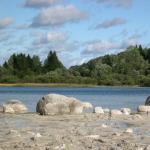
Lake Maracaibo is, strictly speaking, a lagoon of the Venezuelan Gulf of the Caribbean Sea, connected to it by the narrow shallow Tablazo Strait, the width of which is 8-10 km, the natural depth was 2-4 m, in 1957 it was deepened to 10-14, 5 m, for the passage of ocean-going ships. The lake is located in northwestern Venezuela in a tectonic depression between the Northwestern Andes ranges of the Sierra de Perija in the west and the Cordillera de Merida in the south and east.
COLORS OF MARACAIBO
The world of this lake is rich, colorful and famous for one of the rarest natural phenomena.
The vegetation of the lake shores varies along the north-south axis. The shores of the Tablazo Strait are covered with typical savannah grasses, to the south relief The shores rise, more and more rivers flow into the lake, the water becomes more and more fresh, and on the southern coast of the lake, above the swampy lagoons with mangroves, a dense tropical forest rises like a wall, in which many animals live. The cries of howler monkeys can be heard far away. Plantations of sugar cane and cocoa trees lie in drained areas. An interesting testimony from 1806 by the French ambassador in Caracas, François Poe, about the Guajiro Indians: “They are brave warriors, skillfully manage their canoes, and all of them are excellent swimmers and divers. At the same time, they fantasize a lot and write things down all the time, obviously having a penchant for writing. Their women are no less artistic, but have greater common sense.” Creative talent in the guise of guajiros and parauhanos is still noticeable today. Women wear wide, bright and long dresses called manti. Men - wide shirts, decorated with many beads, sewn by their friends, great needlewomen; skillfully crocheted snow-white napkins with the “Sun of Maracaibo” pattern are the main souvenir of the lake.
A rare natural phenomenon occurs above Maracaibo called the “Catatumbo Lighthouse”. The lighthouse is because the light from lightning that flashes at night over the place where this river flows into the lake is visible 400 km away. Lightning strikes in these places more than 160 days a year, 10 hours a day, approximately 300 times per hour. Catatumbo lightning is considered the largest natural ozone generator on Earth. And this phenomenon occurs when an atmospheric vortex from the warm air of the Caribbean Sea and the cold air from the tops of the Andes mixes with methane gas rising from the swamps.
FUN FACTS
■ The Yupa Indians believe that Catatumbo lightning occurs when fireflies collide with the souls of their ancestors.
■ Gaitassoulianas is the name of the musical style of Venezuelan folk music born on the shores of Maracaibo. These melodies incorporate elements of salsa and merengue. She is popular all over Latin America, performed most often during the Christmas holidays.
ATTRACTIONS
■ Rafael Urdanet Bridge (1962, length - 8769 m, maximum height- 45 m), named after the hero of the national liberation movement of Venezuela.
■ Maracaibo: Carabobo Street (colonial architecture), Palacio de Gobierno (Palace of the Eagles - based on the figures of four condors on the roof), Cathedral Maracaibo (XVI-XVII centuries), cathedral Holy Virgin Rosario Chiquinquira, or “La Chinita” (19th century), churches of Iglesia de Santa Barbara and Iglesia de Santa Lucia, Baralt Theater (19th century), memorial “La Chinita”, art center Los Bermudez, Vereda del Lago park on the shore of the lake. Maracaibo, Botanical Garden, Historical Museum, Military History Museum.
■ Fort of the 17th century. on o. San Carlos.
■ National Park Chienagas del Catatumbo (tentatively listed) World Heritage UNESCO).
Atlas. The whole world is in your hands No. 146
South America is the richest water resources continent. The continental river flow is twice the average river flow globe. The main source of river nutrition is rainfall. Rivers are glacially fed only in the southern Andes. The role of snow nutrition is small. The continent is characterized by large river systems. Their formation is facilitated by the flat terrain of the eastern part and the high mountain ranges of the mainland, large contrasts in altitude, and a humid climate.
Rivers of South America
The Andes Mountains are the main watershed of the continent. To the east of the Andes flow large and deep rivers belonging to the Atlantic Ocean basin. They provide 90% of the river flow. Among them are the Amazon, Orinoco, Parana. Originate on the western slopes of the Andes short rivers that relate to the pool Pacific Ocean. (Locate river basins on the map.) The area of internal flow is insignificant (about 6%).
The longest and deepest river on Earth originates in the Andes mountains. Amazon and many of its major tributaries. The Amazon basin is located in a richly and evenly moistened region, where 1500-3000 mm of precipitation falls. The Amazon River is 7,100 km long (with the Apacheta source). The river collects numerous tributaries from the slopes of the Andes, Brazilian and Guiana plateaus. The Amazon river basin is the largest in the world (about 7 million km2). It is almost equal in area to Australia. The waters of the Amazon make up 1/5 of all waters carried into the World Ocean by the rivers of our planet. The desalination effect of Amazon waters on the ocean is evident over 400 km from the mouth of the river. After the confluence of the Ucayali and Marañon rivers, the Amazon is 1-2 km wide. Downstream the width increases to 5 km, and in the lower reaches to 20 km. At the mouth, the width of the main channel with numerous islands reaches 80 km.
The Amazon is full of water all year round, as it is fed by thousands of tributaries. The largest tributaries: the right one is the Madeira and the left one is the Rio Negro. The highest water level in the Amazon occurs after the rainy period in the Southern Hemisphere (in May), when the bulk of it is carried by its right tributaries. The water level in the Manaus area rises by 12-15 meters. The lowest water level is in August and September.
Together with its tributaries, the Amazon forms the world's greatest internal system. waterways with a length of more than 25 thousand km.
From the mouth to the city of Manaus, which is 4,300 km, the Amazon is accessible to large ships. The river has enormous hydropower resources. 1/3 of the species live in the waters of the Amazon freshwater fish of our planet. This is 6 times more than in the waters of all of Europe. The Amazon is recognized as one of the seven natural wonders of the world.
Parana(“silver river”) is the second largest river in South America (4380 km). Like the Amazon, it has two sources (Rio Grande and Paranaiba) on the Brazilian Plateau. Paraná, unlike the Amazon, crosses several climatic zones. This is why the amount of rainfall that reaches different parts of the river basin varies. In the upper reaches of the Parana, most rain falls in summer, in the lower reaches - in winter.
The river makes its way through the solid rocks of the platform's foundation, so it is characterized by rapids and waterfalls. The largest of them is Iguazu Falls. This is not just a waterfall, but a whole system of waterfalls stretching for almost three kilometers.
Situated on the border of Brazil and Argentina, Iguazu Falls is one of the world's most majestic natural wonders. The waterfall falls into the gorge from two steep basalt steps in 275 jets and streams, separated by rocky islands. The total height of the fall is 72 m, width - 2700 m. The roar of water can be heard 20-25 kilometers away.
The third largest river in South America - Orinok o (2730 km) originates on the Guiana Plateau. The Orinoco floods in the summer thanks to the rains. Its tributaries are turbulent, they have many rapids and waterfalls, so they are not suitable for navigation. The Orinoco River is the most important trade route.
The basins of the Parana and Orinoco rivers are located mainly in subequatorial zones, and therefore have a pronounced seasonality of flow - rapid floods in summer and a sharp decline in water in winter.
On one of the tributaries of the Orinoco there is the most high waterfall world - Angel (1054 m).
A huge column of water, foam and steam falls with a mighty roar, as if from the clouds. The waterfall is included in the UNESCO World Heritage List.
Lakes of South America
South America is not very rich in lakes. By origin they are divided into tectonic, glacial, volcanic, lagoonal, and oxbow. The largest glacial lakes are concentrated in the west in the southern Andes. On the interior plateaus of the Andes, on the Gran Chaco plain, the lakes are tectonic, drainless, saline. Along the low-lying shores of the Atlantic Ocean and the Caribbean Sea there are large lakes-lagoons - shallow parts of the ocean, separated from it by land and connected to it by a channel.
The largest alpine lake, Titicaca, is located in the Andes on the border of Peru and Bolivia. Its area is 8300 km2. The lake is located at an altitude of 3812 m, occupying a deep tectonic depression. The depth of the lake is 304 m. It is the largest mountain lake in the world in terms of fresh water reserves.
It is believed that the lake is the remnant of a sea bay. Balsa trees grow around the lake, from which the Indians make rafts and boats.
In the north of the mainland, in Venezuela, the largest lagoon lake, Maracaibo, is located with an area of more than 16,000 km2. It is connected by a narrow channel to the Gulf of the Caribbean Sea. The lake plays an important role in fishing. The most valuable product of his fishery is shrimp.
There are approximately 2,000 reservoirs located in South America. The Parana River is a cascade of reservoirs.
Artesian waters are widely used in water supply to arid areas of South America (Gran Chaco plain, intermountain basins). The most powerful glaciers in South America are located in the southern Andes of Chile and Argentina. There they descend all the way to the sea and form vast ice fields.
Glaciation developed in the Patagonian Andes. The largest glacier is Perito Moreno. The glacier area is included in the UNESCO World Heritage List. Its area is 250 km2, width is about 5 km.
South America is the richest continent in water resources and has a dense river network. Most of the runoff occurs in Atlantic Ocean. The longest and deepest river in the world - the Amazon - flows here, and there are two largest lakes - Titicaca and Maracaibo. The main source of river nutrition is precipitation. Rivers are used as sources of fresh water, they have large reserves of energy resources and are important transport routes.
In Bolivia, on the high plateaus there are many lakes - salty and fresh. One of them is Laguna Colorado(Spanish Laguna Colorado; ketch. Pukaqucha) - shallow water lake, saturated with mineral salts, located on a vast (Spanish: Altiplano), in the territory National Nature Reserve Eduardo-Awaroa(Spanish: Eduardo Avaroa Andean Fauna National Reserve) in the southwestern part, near the border with, at an altitude of 3.8 thousand m above sea level.
The surface area of the lake is almost 60 km², but its depth rarely exceeds 30 cm. The shores of the reservoir are rich in sulfur and sodium deposits, and in many places are covered with a layer of borax - evaporated salt, which also forms numerous snow-white islands in the lake itself.
Laguna Colorado is surrounded by picturesque cliffs and boiling geysers. The stunning landscapes here, stretching against the backdrop of the sparkling white Andean peaks, look unearthly, as if you miraculously found yourself on another planet.
Photo gallery hasn't opened? Go to the site version.
Description and characteristics
Laguna Colorado is one of the important natural sites of international importance included in the Convention on Wetlands (1971). In 2007 amazing mineral lake was among the nominees for the title of one of the seven New Wonders of Nature, but based on the number of votes, it did not make it to the finals of the competition.
The lake refutes generally accepted ideas about the color of water: contrary to natural laws, the waters here are not the usual blue or green, but red-brown, which, along with the surrounding Martian landscapes and the flocks of flamingos that have chosen this region, gives the lagoon a uniqueness and special flavor. The unconventional color of the water, which, depending on the time of day and air temperature, acquires various shades of red (from pinkish to crimson), green and deep purple, is explained by the pigmentation of the seaweed and salt deposits present in it, as well as local sedimentary rocks. The combination of burgundy-terracotta water with snow-white islands of borax creates an amazing play of colors - an unforgettable fantastic sight.

Because of the strange color of the water, the lake is often called Red
In summer it is quite warm here, but at night the air temperature often drops below 0°C.
Tourist excursions to the lake should be taken during the warm season, when natural landscapes abound in all kinds of colors.
Flora & Fauna in Laguna Colorado
The Red Lagoon, rich in plankton, is home to almost 200 species of migratory birds. Despite the harsh local climate, the lake of rare beauty is favored by numerous flamingos (about 40 thousand). The Laguna Colorado region is home to many representatives of the rare South American species of flamingo - James' pink flamingos(lat. Phoenicparrus jamesi). Despite the fact that there are very few of them left on the planet, beautiful birds accumulate in large numbers on the shores of the lake and are in this area invariably throughout the year, only periodically flying outside its boundaries.
 You can also find Andean and Chilean flamingos here, although in much smaller quantities. Exotic birds wander in shallow water or stand picturesquely with their beaks dipping into the water.
Flamingos are especially beautiful at dawn, in the rays of the rising sun. The plumage of birds acquires a pink color due to plankton, which is abundantly present in the bottom layer of the lake, which they eat in huge quantities. By the way, once in captivity, pink flamingos very quickly become ordinary white birds. In order to fully enjoy the view of the majestic flamingos in the morning, you can stay overnight in a small hotel located right on the shore of the lake.
Despite the tough climatic conditions, in the area there are vicunas, pumas, alpacas, llamas, foxes, chinchillas, and reptiles.
At a distance of about 100 km from Krasnoe there is Green Lake, and between them lies a thermal zone consisting of hot springs, mud volcanoes and fumaroles - jets of hot volcanic gas and steam escaping from cracks. Of course, Green Lake is inferior in unusualness to Red Lake with its Martian landscapes, but this body of water is surrounded by a chain of smoking active volcanoes.
Nearby is also a small White Salt Lake (Spanish: Solar de Chalviri), along the banks of which there are many warm thermal springs where you can swim. The country's government is trying to take action to harness the geothermal energy of the earth, but so far it has not progressed further than drilling wells.
In recent decades, more and more tourists have been flocking to Laguna Colorado, who are attracted here, first of all, by the unusual color scheme of the fantastic, almost alien landscapes.
Curious facts
- Laguna Colorado with brown-red water is one of the most valuable “pearls” of Bolivia and the most visited place in the country.
- Interestingly, the color of the lake changes depending on the weather and light. The water of the Lagoon can shimmer in different colors, from burgundy-black to greenish and yellowish.
- On the shores of Laguna Colorado, a rather rare species of flamingo, the James Flamingo, lives in such numbers that it is quite difficult to believe the rarity of these beautiful birds. In fact, this lake is one of the few places on the planet where James Flamingos feel at home.
- Back in the middle of the twentieth century, scientists were sure that James's Flamingos had completely disappeared from the world; Only later did it become clear that these rare birds still live in South America.
South America receives the highest amount of precipitation compared to the rest of the Earth's continents. This created good conditions for the emergence of an abundant system of lakes and rivers. They play a serious role in various aspects of the life of humanity and the Earth, among them there is also a tourism component. By the way, some rivers and lakes in South America contain practically no water. But for travelers this does not make them any less attractive. Even, rather, on the contrary - today many people are interested
The lakes of the mainland attract a lot of travelers every year. People come from all over the world to see some of them.
Maracaibo
Many tourists today are interested in exploring South America. Lakes also attract their attention. The largest of them is Maracaibo. But if we consider it as a geographical formation, it has the characteristics of a bay. Its main feature is a rather scary and unique natural phenomenon - the Catatumbo lightning.
Lightning is observed at the point where the Catatumbo River flows into it. Here they strike almost continuously for 9 hours. Almost half of the nights here are illuminated by very bright flashes; they can be seen at a distance of 400 km.
This phenomenon is explained by the collision of methane rising upward. It comes from local swamps, as well as from the Andes, from downward air currents. At this moment, a potential difference is formed in the clouds, which is constantly discharged in the form of celestial electricity.
Peach Lake
Red Lake
When considering the lakes of South America, one cannot help but highlight Red Lake. This is what Laguna Colorado is often called. This lake is located in a reserve called Eduardo Avaroa in Bolivia, at an altitude of almost 4200 meters.

Its uniqueness is based on two factors.
- First: algae “live” in this place, which produces substances that reliably protect them from ultraviolet radiation, therefore changing the hue of the water. Depending on the temperature and time of day, the lake can take on different shades - from scarlet to dark purple.
- Next: this is a place where thousands of flamingos live, among which there are representatives of the rarest species.
Uyuni
Some lakes in South America are characterized by small amounts of water. Likewise, in Uyuni it appears extremely rarely. This is the world's largest salty dry lake, which was formed in the prehistoric period by the transformation of several reservoirs at once.
This giant salt marsh, with a total area of about 10.5 thousand km², is located in Bolivia, in the south of the Altiplano, a desert plain. He contains large reserves salts, lithium chloride.
For travelers who come here during the rainy season, the lake gives an amazing experience. At this time, you get the feeling of driving or walking on a huge mirror, flat and smooth, which stretches over enormous distances.

There are many beautiful lakes on the mainland. Some of them are located in hard-to-reach regions, others are “promoted tourist attractions.” Anyway, see large lakes South America is worth visiting for every traveler looking for unforgettable experiences and vivid impressions.
In the mountains of Bolivia, in the southwestern part of the country, 10 km from the border with Chile, in the territory National Park Eduardo Avaroa National Reserve is located amazing lake with red salt water. It is called Laguna Colorado or Red Lagoon.
Colorado Lagoon on the map
- Geographic coordinates (-22.201527, -67.780132)
- The distance from the capital of Bolivia, Sucre, is approximately 450 km
- The nearest airport is Joya Andina (originally Aeropuerto Joya Andina) about 270 km to the northeast. It is located in the northwestern part of the city of Uyuni, near the salt marsh of the same name
Why this color?
As you understand, the water in the lagoon has many shades of red, ranging from orange, burgundy to brown, and even purple.
The color of the water and its salinity are explained by sedimentary rock minerals dissolved in it and the influence of colonies of certain types of bacteria. Moreover, the colors of the water of the Colorado Lagoon usually change depending on weather conditions, temperature and precipitation.

The Red Lagoon is one of the highest salt lakes on the planet. It lies at an altitude of 4278 meters above sea level.
The dimensions of the reservoir are 10.5 by 9.5 kilometers. The surface area is about 60 km 2. But the depth is much more modest. The average depth of the reservoir is about 35 centimeters. The maximum does not exceed one and a half meters. So you can safely cross this lake on foot, if, of course, such a desire arises and you want to spend several hours in salt water. This is highly not recommended, since the water temperature is far from comfortable.
By the way, there is a similar lake in Senegal (though it is much deeper and warmer). It is called Retba. People still mine salt there, practically being in a salty solution for several hours.
Also interesting are the numerous white islands throughout the lagoon. These are deposits of borax, a mineral officially called sodium tetraborate decahydrate. This mineral is used to obtain boron and its compounds. Its white color contrasts strongly with the red water and blue sky, creating surreal landscapes similar to illustrations from other planets.


Red Lagoon - home of flamingos
The Colorado Lagoon is home to a large population of James's flamingos. For a long time, scientists considered this species almost extinct until they discovered them large cluster on this red lake. According to rough estimates, up to 30,000 individuals gather here. You can also observe, related to this species, Andean and Chilean flamingos.

In addition to birds, in the vicinity of the lagoon you can see Andean fox, chinchillas, llamas and other animals.
In summer it is relatively warm here, but at night the temperature often drops below 0 o C (do not forget at what altitude the lagoon is located).
The average annual rainfall recorded in Colorado Lagoon is 75 mm.
Air temperature:
- Average +8.9 o C
- Maximum average value +10.7 o C
- Absolute maximum +17.4 o C
- Minimum average -8.9 o C
- Absolute minimum -17.0 o C
As you can see, you will have to take care of warm clothes and good shoes.
- About 240 kilometers to the north there is another salt Lake. This is the famous Salar de Uyuni - one of the most famous places on a planet where the sky merges with the earth. It is often difficult to determine where the horizon is
- 65 kilometers to the south there is an equally beautiful and amazing lake called Laguna Verde. There you can also see magnificent flamingos, and the water has an incredible, but emerald, color.
- Colorado Lagoon has been included in the Las Seeps Wetlands and has been a Ramsar Wetland of International Importance since 1990.
- In 2007, an international competition was held to determine the modern Seven Wonders of the World. Laguna Colorado was one of the candidates for a place on this list, but did not receive the required number of votes
- There was no exact information about the origin of the name, but most likely it came from the words color (in English “color”). That is, in general terms we can call this place the “Colored Lagoon”. Connections with American state Colorado not found
Colorado Lagoon photo