1 Plan ancient port Carthage in Africa, 2 Plan of the ancient port of New Carthage 3 Plan of the ancient port of Alexandria in Egypt, 4 Plan of the ancient port of Athens (present-day Fetina).
Carthage
This is what a modern port looks like Carthage:
It doesn’t seem to look at all like an ancient port, but the size of the water space is about the same. If you believe the scale of the ancient plan, 500 toises on which are equal to 1 km. Then the bay in which the old port was located has approximately 7-8 km in diameter (the new port is 5x10 km - measured in the Planet-Earth program), the island in the middle on which the city was located is approximately 4x5 km. The military port (Port des galeries) was located separately from the commercial port (Port Marchand). But the entrance to the military port was through the commercial one. Description of the port of Carthage given in this book:
“On the island of Cohon there was an arsenal navy; its perimeter was approximately 4,000 toises (8 km), lined with the most beautiful stones, the eastern side consisted of vaulted niches capable of sheltering 220 of the strongest ships that were then being manufactured from the heat of the sun. The entrances to these niches were decorated with rich marble columns of the Ionic Order, and at the end there were warehouses for rigging and everything that was needed by the crews of each ship. Two superb porticoes terminated this island at either end; its perimeter, bordered by magnificent piers, included buildings intended to house naval officers; schools where pilots and other students supervising maneuvering were trained. (and I think it was very difficult to maneuver in a confined space with a large number of ships, using only the power of wind and sails (?), my note). There were also docks for repairing the underwater part of the ship and shipyards for the construction and conversion of ships; in a word, every imaginable convenience. In the middle of this island was the palace of the admiral, so elevated that he could see from his house everything that passed in the two ports and beyond. The same splendor was observed in the commercial port, which had to be passed in order to enter the port of warships; its entrance was closed by two large piers, at the ends of which there were 4-story towers, and the distance between them for the passage of ships into the harbor was only 20 tauzes (40 m). Lighthouses were located on the tops of the towers.”
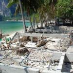
This is what the place that is now believed to have been the Carthaginian port and its reconstruction looks like:
This place is located 2.5 km north of the modern port of Carthage. My opinion: it does not fit the description of the ancient port of Carthage, if only because it has small sizes- the diameter of the water circle is only 300 meters, and the diameter of the central island is 130 m. It could not accommodate everything that is present in the description. It was probably a harbor, but built later. On the same principle as Old Carthage, only in a very reduced version.
New Carthage
Nowadays Cartagena is located in the south of Spain. The Romans called it the new Carthage because it was founded by the Carthaginians. At the time of writing, the configuration of some ports had already been changed. For example, New Carthage, at the time of its conquest by the Roman general Scipio in 209 BC, was located on a peninsula connected to the land by a narrow isthmus. Perhaps this island was artificial? And, apparently, it was built according to the principle of old Carthage.
Manuel de la Cruz: View of Cartagena, 1786, oil on canvas, Madrid, Moncloa PalaceNow this port looks completely different from how it did in ancient times:
Modern view of the port of CartagenaAlexandria
This is how the book describes the founding of Alexandria:
“The Carthaginian Republic was in the most high point power when Alexander the Great, after the siege of Tire, laid the foundations of Alexandria in 332 before the birth of Jesus Christ. This prince, having wandered along the shores of Egypt to the western branch of the Nile, noticed between the island of Pharos and Lake Marea (Mareotida - my comment), a place most suitable for realizing the project he had in mind for the construction of a city worthy of bearing his name.
After the death of Alexander the Great, the Ptolemies ( dynasty of rulers of Egypt in the IV-I centuries BC. e. - in the Hellenistic era - approx. my), having Egypt at their disposal, used everything possible to increase the initial glory of Alexandria: he who was called Philadelphus (king of Egypt in 285-246 BC), has contributed most to enriching it with the works necessary to make it the greatest port in the world. He succeeded in annexing the island of Pharos to the mainland by a large dam, which divided the bay into two separate harbors, connected by passages made in the dam and covered by two bridges, each of which was supported by a fortress. Built in the sea, on a foundation that, like the dam's foundation, was over 36 feet (11 m) deep. The eastern entrance to the harbor was difficult due to the rocky shoreline. But on the eastern cape there was a famous lighthouse, which not only illuminated, but also protected access to the port.
This superb building, worthy of being placed among the seven wonders of the world, was executed under the direction of Sostratus, the most skilful architect of his time; its square base, each side of which was 104 toises (208 m) long, on the ground floor of this magnificent building there was a garrison; in the middle was raised a tower of eight floors, each of which set back into a gallery, magnificently decorated, lined with square slabs of white marble of enormous size. At night, on the top of this tower, elevated 75 fathoms (160 m), there was a large fire, visible at sea for 300 stadia, that is, at a distance of about 20 leagues (96 km).
It's a pity there is no description of what served as the source of the fire? And the description of the lighthouse differs from the modern one both in size and appearance. This is a modern idea of what the Alexandria Lighthouse looked like:
Reconstruction Alexandria lighthouseAthens
An old plan incorrectly shows that the port of Piraeus was located near Athens. In fact, there are 8.5 km between them. This is more accurately shown in another diagram:
Map of Piraeus and Athens: the port, consisting of three naturally isolated bays, is connected to the city by a road protected by the Long Walls, a double wall of about 10 km.It is believed that these walls were built in the 5th century BC. to protect the passage from the port to the city of Athens. Subsequently they were destroyed and restored again. A small section of this wall has survived to this day:
Thanks to such a wall, clearing the road connecting the city with the port, the townspeople could withstand long sieges by land, being able to supply food and other goods by sea.
Modern view of the port of PiraeusSyracuse
1 Plan of the port of Syracuse, 2 Plan of the port of Rhodes, 3 plan of the port of Genoa, 4 plan of the port of MessinaSicily, according to the author, is the most favorable island in the Mediterranean for establishing ports. The most beautiful of these ports was located in Syracuse, the capital of Sicily, and had stunning triple fencing, more than 8 leagues in circumference (38.5 km).
aerial view of Ortigia island in Siracusa, Sicily, ItalyThe ancients loved the number “three”. The next port under consideration on the island of Rhodes also had a triple fortification:
“In former times the harbor of Rhodes was surrounded three rows of fortifications, with extremely high towers, and a deep ditch at the foot of each ring. The first ring surrounded the city beyond the port, and abutted the military arsenal, enclosed in a fortress that included a citadel. The second ring included everything, and the third was built in such a way as to protect the entrance to the harbor from the flanks."
I think many have heard about the Colossus of Rhodes - one of the 7 wonders of the world, built or erected in 280 BC. But for some reason, modern sources are silent about the fact that it was not only a giant statue, but also a lighthouse. This is what is written about him in this book:
engraving of a colossus from a geographical dictionary with a source of fire in his hand“The passage to the inner harbor was between the legs of the colossus, which served as a lighthouse. The colossus was so large that ships passed between its legs with their sails raised. It was planted on the platforms of two towers, each of which was based on a rock. This colossus, which was a 120-foot tall statue of Apollo (36.6 m or approximately a 12-story building - my comment), held a scepter in one hand, and in the other, raised up hand, a hearth, which produced a large flame that served for illumination at night. To maintain the light of this lantern, there was a staircase inside the colossus. The entrance to the inside of the statue was in the sole of the foot. It is said that the Rhodians erected it in honor of Apollo, shortly after Demetrius lifted the siege of the city. It was the first of the Seven Wonders of the World, the work of the sculptor Hares, a student of the famous Lysippos, who took 12 years to build it.
The Saracens, having captured the island of Rhodes in 653, found this colossus lying near the harbor for a long time, destroyed by an earthquake. They sold it to a Jew, who cut it into pieces and collected 7,200 quintals of metal (720 tons); it was worth three hundred talents, or 1,500,000 livres of black coin.”
I wonder what they used as a light source? Is it really firewood? Or Greek fire? The author of the book, unfortunately, does not write about this. Or I couldn't find this description in the text. Greek fire (or liquid fire) is a flammable mixture used for military purposes during the Middle Ages. The first prototype of this fire appeared during the defense of the island of Rhodes in 190. BC. (90 years later than the construction of the colossal lighthouse). It was a mixture of crude oil, sulfur and oil. (information taken from the Encyclopedic Dictionary of Brockhaus and Efron, 86 volumes (82 volumes and 4 additional ones). - St. Petersburg, 1890-1907).
modern view of RhodesNow there are deer in the place of the colossus. It's hard to reconstruct giant statue?
Rhodes. Walls old fortress Modern view of RhodesAre these walls really about 2.5 thousand years old?
Sunken cities of the Mediterranean and Black Seas
I will make a small digression in my story, since there is one interesting point regarding all ports located on the Mediterranean Sea and the water areas connected to them. Actually, this is the entire world ocean, by and large? But let’s not cover it so broadly, here we can at least figure it out locally. Everyone understands that the port can only be located at water level. Since he is directly related to it, and his visitors are ships, they do not know how to fly through the air or climb stairs. True, they can overcome some height with the help of locks or special devices, but sea ports, as a rule, are at sea level. And if the sea level rises, then it rises by one amount over the entire area of the water surface. And accordingly, the shore goes under water by the same amount. And, in theory, all ports should be under water after this? All ports built BEFORE the water level rose. Such a rise in water in the Mediterranean, and accordingly in the Black and Seas of Azov, was. Researchers are now finding the ruins of cities lying underwater along the coasts of Italy, Greece and on the opposite side of the Mediterranean Sea.
Flooded city of Pavlopetri, Greece Flooded city of Baiae, Bay of Naples, ItalyAlexandria, located on the opposite side, is partially flooded:
And the city of Heraklion located not far from it. Now it lies two and a half kilometers from the coast under a 10-meter layer of water.
The ancient city of Acre is considered the Crimean Atlantis:
It was first mentioned in the 4th century BC. And it is believed that the city was completely flooded in the 3rd century AD. The cause of the flooding of the city, as well as other flooded cities, is considered to be an earthquake, as a result of which the coast sank under water. Those. It was not the water that rose, but the land that sank. This may explain the fact that not all ancient Mediterranean and Black Sea ports are now under water, but only some of them. Another option: there was a rise in the water level, and all the ports that have survived to this day were built later.
A large study about the sunken cities of the Black Sea region in series of articles Elena Topsida
Atlantis
Speaking of sunken cities. I discovered an interesting reconstruction of the capital of Atlantis according to Plato’s description:
According to him, this capital was located in a place created by the god Poseidon for his earthly beloved:
“When the girl has already reached marriageable age, and her mother and father have died, Poseidon, inflamed with lust, unites with her; he strengthens the hill on which she lived, separating it from the island along the circumference and fencing it alternately with water and earthen rings (there were two earthen ones, and three water ones) of ever larger diameter, drawn like a compass from the middle of the island and at an equal distance from each other. friend."
Many centuries later, when Poseidon’s beloved had already died, her numerous descendants transformed the place where their Ancestress lived into their capital:
“First of all, they built bridges across the water rings that surrounded the ancient metropolis, building a route from the capital and back to it. ...From the sea they drew a canal 96 m wide and 30 m deep, and 50 stadia (9.6 km) long, right up to the outermost of the water rings: so they created access from the sea to this ring, as if to a harbor, having prepared a sufficient passage even for the largest ships. As for the earthen rings that separated the water rings, near the bridges they dug channels of such width that one trireme could pass from one water ring to another. On top they laid the ceilings under which navigation was to take place: the height of the earthen rings above the surface of the sea was sufficient for this. The largest water ring in circumference, with which the sea was directly connected, had a width of 3 stages (576 m), and the earthen ring that followed it was equal in width; of the next two rings, the water one was 2 stages (384 m) wide and the earthen one was again equal to the water one; finally, the ring of water that encircled the island in the middle was a stadia wide (192 m).”
This description is interesting because it repeats the basic principles of ancient Mediterranean ports and star fortresses: alternating three rings of water with two rings of earth, and a long canal or road (in the case of Athens) connecting the seashore with the city. Were these ports and fortresses built on the principle of the capital of Atlantis? Or were they built at the same time? And Atlantis sank not at all 9000 BC, but at the same time as Alexandria, Heraklion, Bayi, Pavlopetri and the ancient cities Black Sea coast? Or were they simply built according to the same principle, now unknown to us?
Fortress of Lille, FranceThe same three water rings and two earthen rings, only not round, but star-shaped.
We return to our ports.
Genoa
From the description in the book it follows that in 206 BC. this city already existed and flourished, which does not coincide with the official version. But personally, I’ve gotten used to it a long time ago.
“At the time when the Romans completed the conquest of Italy, Genoa, one of ancient cities Liguria was already beautiful and prosperous. It was in its port that the Carthaginian general Mago approached in the year of Rome 548 (206 BC - mine) with a fleet of 30 warships and a large number of transport ships laden with warriors, who joined the Gauls against their common enemies. This port, now richer and more prosperous than ever, is formed by a bay that faces south and is protected by a projecting headland on the east side. Which led to the emergence of a navy among the first inhabitants of Genoa, since in this place the ships were protected from cross winds.”
About Liguria from the encyclopedic dictionary of Brockhaus and Efron:
The peoples of Italy in the 6th century BC. e.“The name Liguria comes from the once powerful pre-Indo-European people of the Ligurians, whose sphere of influence in prehistory reached the north of Europe until the Celts drove them back to the Mediterranean coast where they originally came from. The ancestor of the Ligurians was the archaeological culture of square-necked vessels. Under the Romans, the Ligurians were quickly assimilated."
In general, the Lirugi are a people who lived in Italy before the Romans arrived there. Just like the Etruscans and Illyrians. The question of who the Etruscans and Illyrians were and where the Romans and Greeks came from, who drove them out of these territories, is too big to be considered in this article. The port of Genoa, in my opinion, has remained virtually unchanged since those prehistoric times:
Port of Genoa, modern viewMessina
Description of the port of Messina:
Modern view of the port of Messina“Among the other ports of Sicily, Messina seems to deserve special attention for its position on the strait, called the Lighthouse of Messina, so formidable in the reason for the fury of its currents, underwater reefs and abyss, which the ancients called Scylla and Charybdis, located at their northern entrance, whose passage is so dangerous that when the ships are carried away by the force of the current or the wind, they have no chance of salvation.
If we consider the port of Messina, we cannot deny that it is truly worthy of admiration; it is protected on the eastern side by a peninsula or cape, at the end of which is the castle of San Salvador, which protects the entrance together with batteries, not to mention a citadel, recently built, which commands respect on all sides. This port, which extends along the city, almost 1,500 toises (3 km) in length and width, is in excellent condition."
Nothing remains of the fortress of the star and the tower; of the castle of San Salvador there is a wall with a column, obviously built in our time:
Between Scylla and Charybdis or the Hypeborean Whirlpool
It is believed that the expression “Pass between Scylla and Charybdis” means to pass between two mythical monsters, one of which represents a rock, the other a whirlpool:
Mythical monsters, mythical Hyperborea. What do they have in common? And the common thing is the Rock and the Whirlpool. Remember the description from the Mercator map:
“There was an unknown country there, which consisted of four main islands located in a circle around the Pole. Four large inward flowing rivers connected the world's oceans with inland sea, in which a large black rock jutted out exactly at the point of the pole, having a circumference of 33 nautical miles, and almost reaching to the sky: the Black Rock. This rock was magnetic, which explains why all compasses point north. Due to the speed of the inward flowing water, a large gyre or vortex formed around the rocky island, in which the water eventually disappeared into the depths of the earth."
Perhaps something similar to what the authors of the film tried to portray" star Wars rogue one":
My guess is that the entire continent of Hyperborea was an artificial structure. And perhaps this installation in the center of the continent contributed to the creation favorable climate on the continent, and maybe on the whole planet? Is the Gulf Stream an echo of it? Is the myth of Scylla and Charybdis a description of this installation?
But besides the Gulf Stream, there are also local whirlpools in the world's oceans. They are shown in this diagram:
M2 tide, tide height shown in color. White lines are cotidal lines with a phase interval of 30°. Amphidromic points are dark blue areas where white lines converge. Arrows around these points indicate the direction of the “run around”.Officially, they are not called whirlpools, but amphidromic points. But we read what these points represent:
“An amphidromic point is a point in the ocean where the amplitude of the tidal wave is zero. The height of the tide increases with distance from the amphidromic point. Sometimes these points are called tide nodes: the tidal wave “runs” around this point clockwise or counterclockwise. The cotidal lines converge at these points.”
Some whirlpools spin clockwise, others counterclockwise. They always move at the same speed and make 1 full revolution in 12 hours 25 minutes, i.e. about 2 times a day. This is believed to be due to the rotation of the Moon around the Earth.
And if the Mediterranean ports had complexities in their structure, then the ports of the Atlantic coast of France had (and still have) complexity many times greater. Look at the pattern of whirlpools. The tide in the Mediterranean Sea is practically absent, while off the coast of France it reaches 12 meters in some places. I already wrote about this in part 1, describing the complexities of the Dunkirk port.
Ports of the west coast of France
1 Project for the creation of the port of La Hogue, 2 Project of the port of Cherbourg, 3 Granville, including the project of the port and the inner harbor that should be formed there Modern view of the port of La HogueThe areas going under water during high tide are clearly visible.
Modern view of the port of CherbourgAlmost nothing remains here from the old port. Round forts at the ends of the pier were built in the mid-19th century. But one of them was destroyed during the 2nd World War:
Fort de l'Est (eastern end of the long sea wall), dilapidated during World War IIThe second one is alive:
Fort de l'Ouest (western end of the long sea wall) Modern view of the port of GranvilleThat's all for now. Until next time.
An illustration of the siege of Carthage from the computer game "Total war rome 2" was used in the design of this article.
Updated: June 30, 2018On west bank On the island of Crete there is an amazing archaeological treasure of Falasarna - an ancient port, the only one in the world and unique of its kind. This place takes us back centuries to a long-lost culture that left behind many mysteries and traces of its existence. Combination of unique natural phenomena, associated with the fall and rise of sea levels in the western part of the island of Crete, as well as a powerful destructive earthquake in 365 AD, created an artificial harbor and raised land from the sea, revealing the treasures of the great civilization that flourished during the time of Alexander the Great.
Archaeologist Elpida Hadzidaki devoted 20 years of her life to the research and excavations of ancient Falasarna so that we could see the ancient Acropolis, two cemeteries and the ancient port.
The uniqueness of the ancient port of Falasarna
The artificial harbor of ancient Falasarna was built in the 4th century BC. during the time of Alexander the Great using a method combining Phoenician and ancient Greek shipbuilding technologies.
One of the most powerful earthquakes in the entire history of the Earth, which occurred in 365 AD. e. led to the disappearance of Falasarna and its culture, but left a unique legacy for contemporaries. The uplift of the western part of Crete led to changes in the underwater infrastructure, bringing port facilities onto land, which allowed archaeologists to explore the bottom of the sea...on land.
Two years ago, a large part of the ancient embankment was discovered, which was perfectly preserved. Even the mooring sites of triremes (warships) with traces of ropes have been preserved, and there are no analogues to such finds anywhere else in the world.

Various flood protection structures and traces were also found, which indicate that there was previously a flood in Falasarna, and people were looking for ways to protect themselves from natural disasters.
The Rise and Fall of Ancient Falasarna
Falasarna has been inhabited since Neolithic and pre-Minoan times. Many people here were destroyed during the Bronze Age during earthquakes, so the frightened inhabitants left Falasarna for 2000 years. Then, around the 8th - 7th century BC, the Dorians from Laconia came to Falasarna and began building a new settlement on the old ruins.
A state was created that functions in a normal legal regime and has political system, which became the impetus for the development of a progressively developing society. Falasarna was one of the first cities to have laws engraved in stone and placed in temples (especially early in the era). The state had a Doric system of government like Sparta, but without a king. There were no kings, there were rulers, a senate, a national assembly and slaves. In general, there was a democratic system, as was the case at that time in Athens, Sparta and other Greek cities.
The main economic direction of Falasarna was the sea routes, thanks to which it was an international shopping mall with broad economic and cultural ties with the peoples of the east.
At the excavation site in Falasarna, many coins were found from various ancient cities of Crete, such as: Kydonia, Polyrhinia, Eleftherna, Aptera, as well as from Sicily. Which means that there was trade and exchange of products. Vessels from Egypt, with which trade relations developed, were also found.
Falasarna's naval superiority was so great that she controlled the entire coast of the western part of the island of Crete from Cape Krios to the island of Antikythera. Thalasarna flourished from the 4th century BC, when Persian gold began to enter the Greek world in order to stop Alexander the Great's advance against King Darius and his empire. In Falasarna, with money received from the Persians, they began to increase the height of the city walls and erect military buildings.
One of the sources of income for the city-state of Falasarna was piracy and the organized slave trade, which in turn provoked the wrath of Rome. Falasarna was first destroyed by the Romans in 67 BC. during the famous expedition of Pompey the Great against pirates from Cilicia (in ancient times, the southeastern region of Asia Minor), as well as during the military operation of the commander Quintus Caecilius Metellus against the Cretan cities.
Analysis of data obtained from excavations shows that after the destruction caused by the Romans, there were two major natural disasters in Falasarna. According to stratigraphic data, the first disaster occurred in 66 AD, it was a tsunami from a strong earthquake. The second and final blow to Falasarna came largest earthquake in human history in 365 AD, when the western part of the island of Crete rose 6.5 meters from the depths of the sea in a few seconds, after which a huge tsunami covered the port with tons of mud and sea sediment for 1600 years.
A glorious civilization that flourished for 300 years is lost and remains buried underground in Falasarna, waiting to rise to the surface again centuries later.
Chapter “Ports” of the subsection “Architecture of the Roman Empire” of the section “Architecture” Ancient Rome"from the book "General History of Architecture. Volume II. Architecture of the Ancient World (Greece and Rome)” edited by B.P. Mikhailova.
During the era of empire, there was a further increase in the volume of maritime trade in the Mediterranean. The number of ships and their tonnage is increasing, as well as the amount of maritime transport. This process naturally requires the construction of new ports and the reconstruction of old ones. In the first centuries AD. giant ports arise, such as Ostia, Carthage, Alexandria.
All ports, including those using natural harbors, had artificial structures of various types: breakwaters, breakwaters, dams, lighthouses, etc. Small ports had one basin for parking, unloading or loading ships, the largest ports had several.
The simplest type of port (the ports of Trajan at Centumcelli and Tarracina in Italy and the port at Caesarea in Palestine) with one basin could have a different structure. They tried to use a bay or lagoon as a basin for the port (for example, the port of Claudia in Ostia, Fig. 165), equipped with a number of artificial structures. In those cases when economic or other needs forced the construction of a port in a place where there were no bays, an artificial bay was created, protected from the sea by breakwaters. Sometimes the pier ran in a long strip along the shore, separating the port from the sea. More often, however, ports were built with two piers and a narrow passage between them.
In the II century. AD very popular were ports whose basin had a round or polygonal shape in plan (for example, the port of Trajan in Ostia). The convenience of this type was the long length of the berths, which allowed a large number of ships to moor at the same time.
Ports with not one, but several basins were widespread. Going back to the type of Hellenistic port, where one basin was intended for trade and the other for military ships, they largely lost their military function during the imperial era. All the largest ports of the empire, as well as many others (Tire, Sidon, Cyzicus) belonged to this type. Sometimes a system was used that combined naval and river ports(Ostia, Antioch in Syria). To improve navigation conditions in such cases, canals were often built.
Much attention was paid to the construction of lighthouses. The canal connecting the port with the sea was often divided into two branches by a natural or artificial island on which the lighthouse was located. One of the branches in this case was intended for entry, and the other for exit of ships.
The port was considered not only as a utilitarian structure, but also as a monumental ensemble. Particularly notable was the entrance where they were erecting tall towers lighthouses. Porticoes were usually built along the piers, and on the piers triumphal arches, and in the depths of the port complex there are temples of sea deities.
Pierre Tallet, a professor at the University of Paris at the Sorbonne, told Haaretz (Israel) that in 2013 in Egypt, on the shores of the Red Sea, in the Wadi al-Jarf area, archaeologists discovered a port, which, according to experts, was built 4,600 years ago. The port, in all likelihood, served to deliver materials for the construction of the Great Pyramid of Giza (Pyramid of Cheops). Pierre Tallet's group found this ancient harbor not far from the huge archive of papyri they discovered, which is the oldest of all known repositories. A small portion of these finds was exhibited at the Egyptian Museum in Cairo in the summer of 2016.

 They describe the structure of the state, daily life pyramid builders, but the process of transporting building material from the port to Giza. The ancient documents are very well preserved: the length of some sheets reaches a whole meter. The discovery finally refutes naive stories about the use of mysterious technologies inaccessible to modern man.
 In addition, the archive contained accounting records - tables displaying daily or monthly supplies of food from different places, including the Nile Delta. They mainly transported bread and beer for the port workers. Since the harbor is located far from Giza, it was most likely that ships loaded with copper and minerals from which construction tools were made came into it.
Pierre Tallet believes that the open port gives an idea of how Cheops ruled, ordered and organized his subordinates almost 5 thousand years ago. The pharaoh was not only a great pyramid builder, but also a merchant, because the ancient Egyptians traded in all the coastal cities of Red and Mediterranean seas. Ancient Egypt inextricably linked with ship craft, sailing boats could sail up to 80 kilometers a day and were used not only for trade, but also for military operations.

Talle told Haaretz that the buildings were most likely warehouses for food and materials for workers, lodgings for sailors, and administrative centers who were responsible for the operation of the port. Near them, 99 stone anchors were excavated with red inscriptions - the names of the ships; some anchors even had preserved ropes tied to them. Impressive organization for such an ancient era!

However, modern Egyptologists doubt the “black legends about Cheops” and believe that Herodotus overestimated the required number of pyramid builders. According to Pierre Tallet, recent calculations have shown that in fact 5 thousand people are needed for construction, or, if we take into account the people who delivered raw materials to Giza, no more than 15 thousand people. Another misconception is that the Egyptians were treated like slaves at the construction site. In reality, they were free artisans who served under the royal administration, and, judging by the records on the papyri found, they were quite privileged persons.
Tiwanaku, or Tiaguanaco - the ruins of a mysterious ancient city, which is located in the Andes at an altitude of about 4000 meters. This place is located 19 kilometers from the beautiful lake South America- Titicaca. Scientists believe that the secrets of this ancient Indian city are connected with it. However, is it Indian? But first things first. Let's start with the lake.
Titicaca is a very beautiful freshwater lake with an area of 8,370 square meters. km. (for comparison the area Lake Onega equal to 9,700 sq. km.). It is located on the Altiplano plateau on the border of Peru and Bolivia at an altitude of 3800 meters and is even navigable. Geologists have discovered very Interesting Facts from the life of this lake. It turns out that in the past this territory was located much lower, and the lake was a sea bay. This is evidenced by traces of the surf on the rocky shores, as well as the unusual fauna of the reservoir. Vysokogornoye fresh lake, located 250 kilometers from Pacific Ocean and not having a connection with it through rivers, they inhabit mainly marine species fish and crustaceans. Researchers suggest that a terrible geological disaster occurred here in the past, causing a sharp rise in this area of land. In Inca mythology, there are also legends on this occasion, telling about a terrible flood that hit the world.
 In the photo: panorama of the Kalasasaya temple in Tiwanaku
 This is evidenced by the remains of the city of Tiwanaku, which, according to researchers, was previously a major seaport and was located on the shores of Lake Titicaca. About what happened terrible disaster The remains of people, found together with household items, fragments of buildings and other objects not at all typical for traditional burials, also speak. And a number of city buildings resemble a sea promenade. This city was the center of the Andean civilization of the same name. What remains of it raises more questions among researchers than it provides answers. The time of construction of the ancient structure is not precisely determined, and inside the city there are buildings of different ages. In all likelihood, the city was built, completed and rebuilt for more than one millennium. Some researchers believe that the oldest parts of Tiwanaku were built in 200 BC, with later structures dating back to 600-1000 AD.
 In the photo: Gate of the Sun
More ancient buildings are noticeably different from the newest buildings. These are, for example, the Gate of the Sun and the Kalasasaya Temple. They are composed of giant slabs with perfectly straight edges, which fit together with amazing precision. Many researchers doubt that all this was built by the Indian civilization. Most likely, these are the ancient remains of a city of a more highly developed civilization unknown to science. And the Indians who came here simply used the preserved foundations and sections of buildings, eventually completing them.
The fact that Tiwanaku and Lake Titicaca are closely related is also evidenced by a relatively recent discovery at the bottom of the lake. In 2000, an underwater temple was discovered here, reached by stone steps, and its age dates back to approximately 500 AD. Moreover, the steps lead to a high mountain path on land. The temple measures 50 by 200 meters, and there is an agricultural terrace near it. The location of the temple at the bottom of the lake also raises a lot of questions and has not yet found an intelligible explanation.
 In the photo: the wall of the Kalasasaya temple, laid out in perfectly even blocks
 The ruins of the city of Tiwanaku are classified as objects World Heritage UNESCO. Research into Lake Titicaca and the ancient city associated with it continues. And there is no doubt that a lot of interesting things related to the ancient civilizations of our planet will still be found here.