16.06.2014 11:52
Sacred Valley
Urubamba Valley (another name is ) is a valley formed by the Urubamba River in the Peruvian Andes near the city of Cusco and the ruins of Machu Picchu. Belongs to the modern province of Cusco. During times the Incas were a sacred place.
Going to the Urubamba Valley, I knew absolutely nothing about the history and culture of the Incas. Well, except this. Now, after I went there, looked with my eyes and touched with my hands, I can say with confidence that now I don’t know much more.
Having visited Sacred Valley, everyone probably returns from there as a believer - it doesn’t matter who believes in what, but for me personally, due to the lack of knowledge, it is much easier to believe in Christ and Viracocha than in the fact that all these structures were erected by a civilization that did not know the wheel and writing ...
In the morning the bus docked at the bus station in Cusco. It took us half an hour to sort out tickets for subsequent evacuation from here in a couple of days, then we took a taxi to the center, where we dropped off excess things at the hostel that Bruce (our friend from Lima) recommended to us.
Now we need to figure out what to do next. In the evening we need to be in , in order to go from there by train to Aguas Calientes, a town at the foot of Machu Picchu.
Eduardo, the owner of the hostel, advised us to go to the next square after Plaza Armas and get on a tourist bus.
There were no buses on the square. The first two travel agencies they came across said that all the buses left half an hour ago - at 9 am. In the third office they said that everything would be fine now, the man made several phone calls, spread his arms and said reassuringly - mañana.
In general, we are done with the excursions, now we need to look for some kind of minibus or, in extreme cases, a taxi. But, as always happens, a huckster jumped out from around the corner and promised to arrange everything, took us to the next square, pushed us onto a bus with schoolchildren, took the money and ran away.
The schoolchildren were furious and screaming, it was unclear, the tour guide on the bus spoke only Spanish or sometimes English, and we had absolutely no idea where they were taking us, but we did not stand still, and this was encouraging)
The first two dozen kilometers are markets. All roadside villages sell quilted jackets made from llama and alpaca and all sorts of other useful and not so souvenirs. Everyone definitely stops at one of these markets. sightseeing bus. At the same time, tourists are told sad story that the village where the market stands was recently destroyed by an earthquake or washed away by the waters of Urubamba.
The next stop is a jewelry store where they sell real Inca silver. The real thing here is nowhere else in general.
We stopped and went out into the street - a dusty roadside, mountains on either side, devastation - well, just like our Caucasus.
Peruvians are either fighting corruption, or vice versa, but you cannot buy tickets at the entrance to many archaeological complexes, and where you can, they sell “passes” for 5-10 places scattered throughout the valley. Somewhere in the middle of the road the bus stops, on a cliff there is a booth where they sell season tickets. A new ticket sales office is being built nearby.
It’s no worse here than in Tajikistan :) 
Sacred Valley of the Incas, Peru
But it's worth moving away from modern civilization, and the real Peru begins, the one for which it’s worth coming here.
We in the Sacred Valley.
We bought the tickets - now touch the stones. We are going to the archaeological complex of Pisak. 
The Incas grew corn and potatoes on the terraces, and lived in a city above the terraces. 
We had an excursion for local schoolchildren, who don’t need all these ruins for nothing - well, there are piles of stones here, well, they have lain for a thousand years and will lie there for the same amount of time. Most of the time, the guide was trying to gather all her monkeys together so that they wouldn’t get lost and fall into the abyss, so little adequate information came from her. Well, okay, my task is to touch the stones)
What do we know about Peruvian ruins? The fact that the Incas built in such a way that not only a knife blade would not fit between the stones, but also a drop of water would not leak through. Let's go check it out.
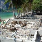
Remains of the house. The wall is propped up with a wooden stick. The building was so-so, but it stood for 500 years, which is probably cool. Not every modern building will have at least one wall left after five centuries, especially in a seismically active zone. 
For some reason local residents They made windows in the walls, and they were blocked through one. Often buildings were adjacent to the rocks with one wall. These walls also had the same niche windows. 
If the lower levels of the buildings are still somehow normally built, then the upper ones are assembled from a mixture of shit and straw. But even this mixture lasts for centuries, washed by showers, like now! 
But I’m not discouraged, I need cool masonry. And now, something interesting. One terrace is made of untreated cobblestones on mortar, and the floor above is good. 
The Inca civilization developed in exactly the same way as modern Muscovite civilization. For example, at first architects were involved in construction, and when everything broke, guest workers repaired it. Not bad. 
And here's the coolest part. Some houses are built from perfectly processed and fitted stones. This is the kind of masonry they tell us about on TV, and they poke knives here, showing the skill of the builders. 
The rain is getting heavier, the clay paths are becoming very slippery, the cliffs are becoming more and more dangerous, we are slowly returning to the bus.
In addition to houses, the Incas also built steep stone water pipes. The “pipes”, starting somewhere in the river, are hidden in the ground and come to the surface in the form of washbasin fountains. In the photo in front of them, the grass on the terrace is trampled. 
These are the things. There is a hole in the bath where the water goes, again somewhere underground. 
We didn’t have time to see a lot here and moved on. We stopped for lunch in the town of Urubamba. Hello civilization. Expensive disgusting food, garbage, in general - modern Peru. 
(Spanish, Quechua Ullantaytampu) - modern city And archaeological site Inca culture in southern Peru, 60 km northwest of the city of Cusco. Located at an altitude of 2792 meters above sea level in the district in Sacred Valley of the Incas.
And now we will go to Oyantaytambo city. This is a place that I really got into.
Those who have not been there will probably not understand my admiration, and four dozen photographs of stones will seem very boring. If so, scroll through)
Welcome . We are at an altitude of about 3000 meters and now we will climb to the terraces. 
Well, let's start with getting acquainted. Viracocha is depicted on the rock opposite the terraces. Viracocha is the creator of the world, the father of the Sun and the Moon, the god who erases civilizations from the face of the Earth and revives them anew.
To imagine the size of the “portrait”, pay attention to the small people on the right side of the frame. 
And one more profile - Inka. On some date of some month, the sun should come out of his eye. 
We met the main inhabitants of the area, now we will walk and study the buildings.
This obscure structure is said to be a granary. Three-stage barn with windows. If you pour grain into the upper windows, then, after filling the room, it begins to pour into the next compartment. Well, for current needs, you need to pick it up from the lowest window. How it really was - I don't know. Maybe I came up with it all myself?) 
We did not have a tour of the complex. The guide said that this was a ritual center, where they prayed and grew corn on the terraces. I set a meeting time and let everyone go for a walk. 
We climbed to the very top. I want to sleep after the bus, and the altitude. In general, it’s hard to climb the stairs, and there are crowds of people around, who are almost invisible in the photo) 
Everything is much more prominent and monumental than in Pisak. The walls of the terraces are made of powerful, processed and fitted stones. 
Find a place that the Incas repaired as best they could, because they didn’t know how to build it the way it was originally built. 
The official version of history says that all of this (and maybe not all, but the main structures) was built in the last hundred years of the Inca Empire, and the most monumental buildings were not completed at all, because the Spaniards came, took everything away and divided what they could to break, they broke, and what they couldn’t, they left as is.
Sacred Valley Inca Peru
Except official history there are also a million alternative versions. The most popular “neovangologist” in Russia (Vangology is the science of predicting the past, author’s note) is the vice-president of the League of Patient Advocates Andrei Sklyarov. In his films and other publications, he predicts many options for the development of the past, which can be treated differently, but I liked his work because he points out some things that most tourists do not notice and do not pay attention to. Maybe this is all nonsense, of course, but it’s much more interesting)
The main idea of the alternative theory is that the Incas did not build anything monumental, and they got all this goodness from the gods, aliens and other dinosaurs.
I listened to all these versions with a smile, and then, when I wandered around and touched the stones, I began to believe that the Incas had nothing to do with it, that they got it all from someone else. Perhaps not from the gods, but perhaps from some previous civilization, which for some reason sawed itself out and did not leave schematic diagram iPhone. Subsequent civilizations have to pray to these ruins and repair them as best they can. 
For example, the wall came apart and a hole was filled in. You will say that it was the modern Peruvians who covered it up, and not the Incas, because during the Incas this wall was just built. Well, it’s hard to argue, perhaps so. 
Here is the corner of the wall, in which a stone “not from here” is clearly built - there is untreated cobblestone around it, but this pebble is of a different type, and is of high quality.
Well, something fell out of the wall here because of the earthquakes, and I suppose the crooked restorers also installed it recently. Anything is possible. 
Ollantaytambo, Peru
Looking at these walls, I believe that they were built by small, hardworking Incas, but they built them in the same way as you built houses from blocks as a child. That is, they got ready-made cubes from somewhere, and they laid them out as best they could, and filled the voids with their main building material - pebbles with poop. 
After the arrival of the Spaniards, people became interested in these ruins only recently, that is, none of the modern people built these walls. If you believe textbooks and Wikipedia, the Incas did not complete the complex, but abandoned construction because of the war. The question arises - where does such hack work come from? Why grind and drag these megaliths from God knows where in order to lay them out so crookedly?
Do you want to say - “you yourself should try to build better from such monstrous stones!” So, I can’t, but someone else could before! 
And I can’t describe this work in a single word, because I don’t know anything more superlative than “ideal.” 
Ollantaytambo Photos
So, scroll up again to the vertical photo and compare the size of the blocks with the size of the people.
Now go back and think about how you can treat the surfaces where the stones come into contact with each other. The complex has many various types masonry, different sizes of blocks, etc., but I can’t figure out how all these stones were adjusted one to one on an industrial scale. Maybe you know?
It seems like a small thing, but try it. 
The wall was also bent. 
HOW??77 
The wall is a little similar to our modern ones, but look, each block is unique. This is a puzzle. You can assemble it by placing each “piece” in its place.
That’s why the Incas created those same walls that I talked about above, where they had to put rubbish between the blocks - the Indians simply didn’t know what to put where, they had a construction set, but no drawing. 
Well, engineers, have your brains started boiling? And now another fashionable wall. 
What is the size of the pebbles? 
The same wall, side view. 
It is believed that these inserts between the magalites are made so that during thermal expansion, as well as during earthquakes, the wall does not crack. 
And in this photo, a group of tourists is trying to see somewhere over the horizon the place where they brought construction materials from. The quarry was located about five kilometers from here. 
Let's give our brain a little rest. Commercial break.
This is a stone. He is not even a piece of a “puzzle”, he is not processed, but all excursions stop before him. Tourists are usually told only the official version of the Incas’ construction of megalithic complexes - like they took wooden hammers, processed the stones, harnessed them and built them, but using the example of this stone, even the right guides talk about the “plasticine” technology for processing the rock. 
In general, it was like this. The stone (the whole or its surface layer) under the influence of forces unknown to us became soft, like plasticine. The Incas (?) took a “knife” and cut off the irregularities, getting a perfectly smooth surface. But, while processing this cobblestone, the worker’s phone rang, he got distracted, lost his mind, and the stone froze again. As a result, the edge of the future brick was not processed to the end; the tool had to be pulled out and the workpiece left cut.
Believe it or not, make up your own legend) 
Let's return to our blocks. Scientists claim that the complex was not originally completed, and tour guides cite this brick lying on the ramp as proof in order to drag it to the installation site. 
On a foundation similar in design lies a block that does not at all look like a slab installed at ground level - it may be a floor beam or a gate element, I don’t know. 
Neo-Vangists believe that the Incas tried to adapt the blocks, but the most they could do was to pile them on these pedestals. 
“Patient advocates” are confident that the temple was completed many thousands of years ago, but was destroyed as a result of a cataclysm - a global flood, for example. Therefore, the blocks on the territory of the complex do not lie neatly, but are scattered, as if after an explosion. 
Some lie on terraces located below the main site, while others hang over the city. 
And the part that most likely should have been the covering of the main gate of the temple generally lies on the lowest platform, although, according to scientists, the blocks were brought from the quarry from a completely different direction. That is, in order to deliver this block here, it was necessary to waste a lot of effort, and then also drag it along the stairs along the terraces to the upper floor. 
It seems to me a completely logical explanation for the destruction of the temple as a result of a cataclysm. Here it stands - one wall is adjacent to the rock, and the other was facing the terraces. Something went wrong and she fell down with a roar. 
Along with the wall, the engineers also died as a result of the cataclysm, and no one now knows how it was built or how to repair it. 
I found a place where you can stick a knife blade between the blocks) You can’t imagine how cool these stones are. 
In some places there are recesses for reinforcement. 
During the time that the guide allocated to us, I never touched all this beauty, so we returned to the bus, took our things from there, sent the schoolchildren further along the route, and returned to the complex and wandered around here until it closed.
Dear friends, team site again presents to your attention a review another World of Tanks game location. Today we will analyze a rather complex and ambiguous map - Sacred Valley wot.
General information.

Picture 1. Minimap.
The wot map Sacred Valley was introduced into the game in version 0.8.6 and after that it was constantly under the special control of the developers. She underwent several major changes, was removed from the game for a long time, and now, not so long ago, she reappeared in the random pool in a new guise. The map has a standard size of 1000*1000 meters, is available for battles of levels 4 - 11 in the only mode of random battles - standard battle. This is a winter map and winter camouflage will be used here.
The map's terrain is one of the most difficult in the game. This is due to the fact that there is practically no level space in the Sacred Valley: constant elevation changes, hills, rocks, as well as various buildings (both destructible and non-destructible). In addition, it is worth noting that artillery has a very difficult time here, since there are very few shots fired, and a stray firefly is able to slip through to self-propelled gun positions at the beginning of the battle.
Take a look at the key components of the Sacred Valley map:

Picture 2. Legend.
If you look closely at the map, you will see how many key components are crammed here, but in order not to overload your pristine brain, I will try to explain them to you as simply as possible. Understanding the map in our game is an extremely important and decisive skill for any player.
- Lower base. It is on the rise relative to the rest of the map, but has several races at once. The perimeter is surrounded by several hills with dense vegetation, where tank destroyers are often used. However, these positions acquire a special role only during a breakthrough from the right flank or center. At the base itself there are a couple of destructible houses, which, nevertheless, are capable of covering tanks when they capture the base. Apart from this, on the Sacred Valley the artillerymen do not have any other positions and almost always stand behind the base.
- Gorge or left flank. The Sacred Valley wot map has two main, but very large and extended flanks. The gorge is one of them and its main part is the center of the gorge, highlighted in a circle. There are a huge number of passages, drives and shelters (including from artillery, which practically does not shoot through here). The relief of the gorge is endlessly stretching, low rocks. The top spawn team has an advantage here, but only due to the fact that most random players do not understand one simple nuance, which we will discuss below. Basically, the winner here is the team that will occupy as many passages as possible, which will allow them to disperse the attention of opponents and fire from unexpected places. Absolutely all classes of equipment can find application in the gorge.
- Center of the map. Located on a lower level than the rest of the map, on the lowland level number 6. It is characterized by many hills, buildings (mostly destructible) and practically does not provide any successful tactics for the game, since both main flanks are separated from center by various obstacles. Can be used at the end of the fight, as this is the closest path between two respawns. However, in the center of this part of the map there is a high rock from which you can play, but not always successfully. However, the presence of at least one tank here will protect your team from a light tank breaking through to your artillery.
- Upper base. Situated on uneven hilly terrain with a large number of destructible buildings. Defeating this base is easier than the lower one due to its location in direct visibility from the team’s main shelters. The artillery here is also located, as a rule, behind the base, behind a hill that completely hides them.
- Central rock.
From the lower part, it is closed by stone walls, but does not have any entrances or passages anywhere. It has no gameplay value, except for the ability to hide from artillery at the foot of a high cliff, in case of emergency. However, some inquisitive minds have found options for racing it on certain tanks, but you don’t need to know about it, and you don’t need it.
Further points 6, 7, 8, 9- these are elements of different meanings and we will analyze them separately, but all of them, taken together, form a single right flank. The second main and no less huge flank on this map consists of several elements and provides many gaming opportunities. The main part of the right flank is the temple, highlighted in a green circle.
- Lowland. An extended part of the right flank, almost from base to base. It is the lowest place on the map. In rare cases, through the lowland it is possible to support an attack on the right flank, but this is not the main direction.
- Climb. Here is a convenient position for highlighting passing enemies from both respawns. Strongly turreted tanks with excellent vertical aiming angles can successfully fight here. From this rise it is possible to drive onto the bridge (numbered 8), which leads to the main direction - the temple (numbered 9).
- Bridge. It does not have any gameplay function, except for one very important one - through passage between the rise and the temple. However, it should be remembered that the bridge is subject to fire from both artillery and any other tanks, which means that the bridge must be used with special care.
- Temple. It is the most important part of the right flank and its center, circled. The second crowd of your team should be concentrated here. The temple is located on a hill, relative to the lowland, and you have to go uphill to get here. As a rule, the battle here is fought by fast and maneuverable tanks, which are able to drive to high ground without losing hit points along the way. There are several large buildings in the temple area, most of which are not destroyed. Behind these buildings you can hide from the gaze of all-seeing artillerymen and exchange fire with the enemy.
So, how to play on the Sacred Valley wot map? Let's try to figure it out.

Picture 3. Positions and directions.
Unfortunately, there is no single tactic on the Sacred Valley map and you will have to act with an eye on your allies, but keeping in mind several nuances that will help you win.
As you can see, there are a lot of possible or probable options for fighting in the Sacred Valley. The map is oversaturated with tricky passages and unexpected places for attack. This makes it very difficult for inexperienced players to understand the map, and therefore I will conditionally divide all attack options into three parts:
- Red direction.
The most difficult and confusing direction is along the left flank. There are an incredible number of narrow passages between the rocks and you can play in almost all passages. The main goal of the teams here is the central part, to control which it is still necessary to capture all the passages leading there in order to avoid being hit in the back. The top spawn team has some conditional advantage: the fact is that they don’t have to think where to go, everything is intuitive, but the bottom spawn team must control the area marked with an exclamation mark on a yellow background! It is very important. If the bottom team does not control this area, then the tanks in the center of the gorge will simply go to the rear and be shot from both sides. Thus, the bottom team needs to use their brains a little to create balance on this flank. In fact, everything is simple, but in random games players often don’t see this and drain the gorge.
The top respawn team moves along the left flank along points that simultaneously serve as defense lines. Fast tanks move out of the direction and go around the gorge from the rear. The lower respawn team is directed to the gorge following the arrows, and positions 1 and 2 serve as defense lines. It is mandatory to control the area with an exclamation mark, as I wrote above.
- Blue direction. A completely optional direction that you can quit. In any case, it is impossible to develop a successful attack from here. It's worth driving here for one or two tanks, clinging under the rock marked with the number 0 on a blue background. There are no good shooting opportunities from here, but you can catch enemy fireflies here. In addition, the allied fireflies, having guessed the right moment, can slip through to the artillery positions here.
- Yellow direction. Everything here is somewhat simpler than with the gorge. Fast, strong-turreted tanks can take up positions on the rise, from which they can illuminate and shoot at passing enemies. Attention, you shouldn’t try to drive more than two tanks here, you simply won’t fit in! It makes no sense to drive through the lowlands under the bridge, since there are no shelters here and you will be in full view of your opponents. Most of your group, who arrived on the right flank, should go up to the Temple and fight here. Again, many random players mistakenly believe that the top spawn team has an advantage here, which is completely wrong. On the right flank, both teams have the same capabilities and the advantage is only due to a larger number of tanks or personal skills.
In addition, there are certain standard artillery positions (brown areas near the base) and Tank destroyer(purple areas, from which it is convenient only to defend, but not to support the attack).
In custody.
This concludes our review of a very ambiguous and difficult map, and the main thing that can be highlighted is a slight imbalance in the balance in favor of the upper respawn. There is nothing critical about this, however, it is not pleasant. Let's wait and hope that sooner or later the developers will pay attention to this.
Sacred Valley of the Incas. Travel notes from Peru April 15th, 2015

Blondes and brunettes, shy women, coquettes and harsh weathered men! I share with you travel notes about the Sacred Valley of the Incas in Peru. I write them on the go: in tuk-tuks and in groups, in markets and restaurants, and post them every day on Instagram.
How to get to Machu Picchu cheaply, the phenomenon of leggings in South America and what is “sweet tsemik”?

It's time to become truly famous. How can you do this on Instagram without food? No way! It's like show business without a bed. So, a fruit salad for $1.3 at the market in the Urubamba metropolis. Everything is organic, farm grown, and gluten free. The fruits are collected during the full moon on the slopes of the foggy Andes by specially trained dwarfs.

Pisak is a psychedelic valley. There are many yoga schools, shamans and enlightened adepts with glassy eyes. A huge part of tourists travel to Peru specifically for shamanic rituals. There are two of them: ayahuasca and san pedro. You could read about San Pedro from Castaneda. His books come with age 16, torment, unwashed long hair and a torn Aria T-shirt. And ayahuasca is a local psychedelic that temporarily blocks the liver. The substance should lead the test subject to enlightenment and answers to important questions. Bad trips happen too. In the Sacred Valley, all this shamanism has turned into a very profitable business. I am very far from drugs and esotericism, so I am not going to participate in this and, moreover, I will not organize ceremonies for our groups. But if you can’t imagine your life without dreadlocks, hashish and orange trousers, and in India you are wanted, Peru is waiting!

You can climb the mountain to the Pisak fortress on foot in two hours (a very hellish undertaking) or take a taxi for $7. Previously, I would definitely go on an expedition. But I feel like I’m already getting old. The old rage is gone. I’m not ready to chop for seven dollars. And once, without hesitation, I spent the night at the airport to save five.
But we went down on foot and saw crazy landscapes along the way. And they looked with sympathy at the people climbing up. In their eyes there was despair, decay and awareness of the meaninglessness of what was happening. I think the pilgrims went down by taxi.

I'm climbing up observation deck, and there is a lonely concert without spectators. Some say Pisac is better than Machu Picchu. It is strange that organized tours almost never visit it. Although the town is only 40 minutes from Cusco. We'll compare these two places soon.

If you look closely, you can see me in the photo wearing a discreet T-shirt with the words “Peru” written on it. I think about the fate of ancient civilizations and why we didn’t take sandwiches to the mountain. Thoughts about lunch were more persistent.

There are many jugglers roaming around South America. They earn extra money on the road: they stand in front of cars at intersections and entertain drivers. I saw them in both Bolivia and Argentina. And this guy is just playing with the local children. For me, the coolest thing about traveling is real life people, not a tourist trap, endless temples and views from glossy postcards.
Europeans who travel here have a lot of iPhones. Although there is clearly an opportunity to buy a fifth or sixth. They have a quality that is not particularly characteristic of us yet. People from first world countries take useful functionality from things and are indifferent to the status component. The legions of small cars in Europe like the Peugeot 207 are further proof. It is not customary to show off wealth. In our country, modesty is synonymous with poverty. Therefore, it is quite normal to buy a Range Rover as collateral for a tiny apartment on the outskirts in which you live with three children. Not to be, but to appear is the main motto of the society of new and fast money.
We already have a layer of wealthy people with different values. But there is still a lot of merchant revelry “for all the money” and like the last time.

Meet the Peruvian tuk-tuk. It differs from its Indian counterparts in its futuristic design and the presence of doors. For those who don’t know, this is a motorcycle with an attached body. I met them in India, Thailand, Cambodia, the Philippines and somewhere else, I don’t remember now. The Philippine tricycles are most similar to the Peruvian version. But in Peru it looks more solid - like a real sports car. Tuk-tuks are always cheaper than regular taxis. I know several stories about how guys in India bought this rattletrap for $1000 and traveled around the country on it for months.

A funny hour and a half in the minibus, and we arrived in Urubamba. In Argentina, travel between cities often took 25 hours. I know that you, like me, have long dreamed of this metropolis. For many years, sunny Urubamba adorned my school diary, and I decorated the walls of my cold den with its posters. And here I am! We go to see the Salinas salt mines (pictured) and the Inca agricultural laboratory of Moray. And to you - sweet tsemik and good day!
P.S. “Sweet Tsemik” is an alarming SMS that I once received from a girl with large breasts. I didn't see her again.

Moray - Inca agricultural laboratory. In this bucolic valley, Michurin’s predecessors conducted their ruthless experiments: they crossed arugula with basil, and tried to grow broccoli with the taste of spinach. At each level of the terraces there is a different soil and microclimate. This is where my knowledge of agriculture ends. I immediately remember Mark Twain's story "How I Edited an Agricultural Newspaper."

In Asia, all backpacker girls wear a simple uniform: flip-flops, shorts, a stretched T-shirt (sometimes two at once). In South America it is somewhat cooler (I am very tolerant), and for some reason most travelers travel around the cities in tights. At the same time, they are not at all shy about the legendary Latin American machos. As a man and an esthete, I support the new trend. But it would be more humane if leggings were not sold to everyone.

We moved to Olantaytambo. It took me about six months to learn this name.

Locals travel around the Sacred Valley in fairly comfortable minibuses. And we are with them: $0.5 for a 30-minute move. I haven’t seen any scary Asian-style local basses yet. In general, even Bolivia and Peru are significantly inferior to Asia in terms of color. But by nature South America much steeper (not counting the Himalayas).

Unpronounceable Olantaytambo turned out to be a cool medieval town built by the Incas. Here they are paved with paving stones narrow streets with channels through which clear (!) water gurgles. All this stuff comes from the Incas, 13th century. One hundred hotels and two hundred latte macchiato restaurants are a legacy of a later era.

We finally got to Agua Calientes (hot waters in our opinion). It was an epic trip. First, three hours on a bus along a hellish serpentine road - nowhere on the Bolivian Death Road. There were no seats, so Yulia sat on a stool, and I sat on the floor on a backpack. Then another 40 minutes along the road a la the Himalayas. And one more taxi, and then 2:45 walking along the rails, at the end - in the dark. Girls, who will go to the Girls in travel Peru bachelorette party - don’t worry, we’ll go by train. There are simply two options - a train for $100 and 4 hours or $11 and hemorrhoids for the whole day. And entrance to Machu Picchu is $55. And the bus up and down is another $24. They squeeze the maximum out of workers! But nothing will stop us. Tomorrow another dream will come true.

Machu Picchu lived up to expectations: a cosmic place. Especially early in the morning, when the clouds cover the city and then move away, and the bulk of the tourists have not yet arrived. I thought it would take all day, but we finished it in 5 hours. True, we did not climb any of the mountains (there are three types of tickets with different levels of access). Everything is well organized. It would have been very difficult to climb up on foot, we were happy that we went by bus. There are a lot of people, of course, and it’s not the season yet. For some reason, the llamas did not show up for work, and Yulina’s dreams of a photo shoot with a llama overlooking MP were dashed.

When I looked at photographs from Machu Picchu, I imagined giant queue to a single location for shooting. It turned out that there are a million options, many terraces, and everyone can fit in somewhere. Admiring the lost city from above is much cooler than wandering around it. There's nothing particularly photogenic there. If these ruins had been in a less picturesque place, I’m afraid they would not have become such an icon. But everything together creates an unreal impression!

The Spanish colonialists knew nothing about Machu Picchu. Having climbed into this distance, you understand why. In 1911, it was discovered quite accidentally by amateur researcher Hiram Bingham. I read about another lost city Inca, mini Machu Picchu. You have to go to him on a 4-day trek, which significantly reduces the number of visitors.

After Machu Picchu, instead of resting, we
Photo review: what to see in Cusco in 1-2 days. Tourist ticket Cusco, route through the Sacred Valley of the Incas.
Cusco is a city in Peru at an altitude of 3400 m above the sea. Former capital Inca Empire. Mentioned in each country.
Of course, I dreamed about Cusco and romanticized his image. The city turned out to be quite earthly. Tourist, chaotic, oversized.
Cusco Hotels
We changed housing three times, more or less ok Hostal Dreams House, rating 9.2, paid 30$ . In summer the same number is $50.
Hot shower and even hot water tap in the sink (a first for Peru!). Clean, comfortable beds, breakfast included, and a full kitchen. Near the San Pedro market.
We were poisoned the day before. We were looking for housing with a kitchen to cook.
For 1-2 nights it is better to rent a hotel near the plaza. Or in the San Blas area with city views if stairs inspire you.
What to see in Cusco in 1-2 days
▫ Sacsayhuaman(Sacsayhuaman), -13.50985, -71.98168
Easily remembered as Sexy Woman. Fortress and temple complex on a mountain within Cusco, 30 minutes walk from Plaza de Armas.
 Sacsayhuaman
 ▫ Plaza de Armas(Plaza de Armas), -13.51674, -71.97882
Main square. Nearby Iglesia de la Compañia de Jesus (Spanish Baroque), Basilica Catedral del Cusco.
There's also McDonald's, Starbucks and KFC here if you're bored. At travel agencies inexpensive tours to the Rainbow Mountains, Machu Picchu, Lake Humantay.
 Plaza de Armas
 ▫ Mercado de San Pedro, -13.5218, -71.98234
San Pedro Market, the largest in the center. Souvenirs, clothes, products. If you are going to Bolivia after Cusco, then you can shop there (more choice, lower prices).

▫ Hatunrumiyoc street, -13.51586, -71.97602
Interesting masonry, huge stones lying end to end without cement. There are shops with souvenirs nearby. The shoes are cheaper than the San Pedro market.

▫ Carnivals— holidays have a schedule. For three days in a row we watched young people walking around the city with an orchestra, everyone singing and dancing.

Viewpoints in Cusco
▫ Cristo Blanco,-13.50956, -71.97809
Statue of Christ over Cusco near Sacsayhuaman, view of the city. Taxi 9 sol ($3) from the center. Free admission. The first photo in the post is from that review.
▫ Iglesia de San Cristobal, -13.51341, -71.98009
Church of San Cristobal. Lookout, photo with alpaca.

▫ Mirador San Blas, -13.51382, -71.97409
Viewpoint and bohemian area of San Blas on the hill. Jugglers, artists, musicians, designer stores.

Sacred Valley of the Incas
The Valley of the Incas (Valle Sagrado de los incas) in Peru is usually viewed this way: take a taxi to Cusco for a day 150 sol (≈ 50$ ) and follow the route Cusco - Pisac - Chinchero - Maras - Moray - Ollantaytambo, in Ollanta take the train to Machu Picchu.
Taxi on the Internet is $100-150. On the streets of Cusco it is 2-3 times cheaper. To bargain. There is Uber, but there are few cars.
Maras— salt mines, entrance 10 salts (3$ )
Pisak- ruins and market
Chinchero— ruins and church 1607
Moray- Inca terraces
Ollantaytambo— ruins, the train to Machu Picchu is cheaper from this city
5 places in one day is a gallop, but quite realistic.
Cusco is at an altitude of 3400 m. There is a chance of mining if you fly directly from Lima or come by bus from the coast. To stay alert, we don’t spend the night in Cusco, but go straight to Urubamba (2870 m) or Ollantaytambo (2792 m).
From Ollanta to Machu Picchu by train (from 70$ ) or transfer ( 10$ ). We see the Sacred Valley and Cusco on the way back.
Tourist ticket to Cusco
Day 3. Moray
▫ Hiking to the terraces, all day

Day 4, rest
Day 5. Urubamba → Ollantaytambo
▫ Minibus to Ollantaytambo, 2 sol ($0.6), 30 minutes
▫ Ruins, rest
▫ Overnight at Killari Hostal
Day 6. Ollanta → Hydroelectrica
▫ 9.30-15.00 – transfer to Hydroelectrica, 35 sol ($10)
▫ 15.00-18.00 - walk from Hydroelectrica to Aguas Calientes, 11 km
- Location: Peruvian Andes, Cusco Province
- Main attractions: Machu Picchu, Pisac, Olntaytambo, Cusco
Manifold historical monuments and the secrets of ancient civilizations - these two factors primarily attract tourists to. Despite such a flow of travelers, this country has still retained its level of development at the stage where, if desired, you can meet real Indians in the markets, the local color is sometimes captivating and surprising, and the ancient ruins are still carefully preserved, and no one asked to highlight this area is being developed with modern skyscrapers. With a relatively undeveloped economy, this country is a true paradise for tourists. Well, a very special and probably the most significant place in is the Sacred Valley of the Incas - Urubamba Valley.
Cradle ancient civilizationPerhaps one of the keys to unraveling the mystery of the ancient Incas is the Urubamba River. Like Egypt and the Nile River, the valley along Urubamba was rich in fertility and good climate, while all other regions of Peru were experiencing debilitating drought. This fact allowed the Inca civilization to concentrate its forces and capabilities not only on agriculture and food production, but also to devote part of its time to the conquest of adjacent territories, as well as exploration of the surrounding world. What is characteristic is that the Incas even stepped forward in agriculture - it is believed that it was in the valley of the Urubamba River that they first began to grow potatoes.
The Sacred Valley of the Incas is located in the Andes, between and, along the Urubamba River. It covers and includes all significant monuments of ancient civilization. Salt and agricultural terraces, picturesque towns, majestic temples, fortresses and ceremonial complexes can all be found in the Urubamba Valley in Peru. Every captured landscape, every frame taken in this area looks like a postcard - it’s so colorful and picturesque here.
Attractions of the Sacred Valley of the Incas
- Machu Picchu. Probably even the most notorious homebody who does not want to expand his knowledge about outside world, have heard about this city at least once. This is the main attraction not only of the valley, but of the entire country. The ancient city is located on a rock in such a way that it is practically invisible at the foot of the mountain. Its construction dates back to the 15th century. Today Machu Picchu is included in the list of objects world heritage UNESCO.
- . This is an entire archaeological complex, which is one of the most important monuments of ancient civilization in the entire Urubamba Valley. It was originally intended as a fortress, but over time it became a ceremonial center. Among other things, Pisac is famous for its astronomical observatory.
- . This city is the best preserved to this day. Residents even converted some buildings into modern housing. But the main highlight, and at the same time the mystery of this place, is the Temple of the Sun, the wall of which is made of huge monolithic blocks. Ollantaytambo was at one time an important religious, administrative, military and agricultural center of the Inca Empire.
- . Ancient capital Incas and one of the richest cities of ancient civilization. Before the conquest by the conquistadors, the city was surrounded by luxury, and the Temple of the Sun was decorated with pure gold. Today it is the second most popular city in Peru after.
- Moray. This place is an archaeological complex, among which unique agricultural terraces stand out. They have a circular shape, gradually narrowing from level to level. There is an assumption that Moray served as a kind of laboratory for the Incas, in which they observed the growth of various varieties of certain crops.
- Maras. These are also terraces, but narrower. Having established a unique water supply system, water from the depths of the earth fell into many grooves, where it dried, leaving salt crystals. Tellingly, salt mining continues here in our time.
- Chinchero. This was once the main residence of the Inca Tupac Manco Yupanqui. However, after the conquest of these lands by the Spaniards, everything was redrawn in a Catholic way, and a Catholic cross was erected over the Temple of the Sun. However, it is still an interesting and colorful place. Among other things, Chinchero is famous for its fair, where many handicrafts are sold.
- . These are peculiar paths intended for walking. Basically, the name “Inca Trail” is associated with such a path near Machu Picchu, but it is completely wrong to think that this structure is here in a single copy. Such trails can be found in different parts of the Sacred Valley of the Incas.
- City of Urumamba. This small town attracts those who want to touch the ancient mystery, but do not tolerate climbs and heights, since it is located in a lowland. In addition, here is the residence of the Supreme Inca Huayna Capac, for the construction of which the course of the Urubamba River had to be changed.
- . This amazing place associated in some way with the resort. There is a whole water complex here, including baths, various canals and aqueducts. By the way, water still flows here today.
- Pikiyakta and Rumikolka. These are two different structures, but their essence is the same. Ancient city Piquiyakta was a kind of checkpoint, and the ancient Inca gate Rumicolca only emphasizes its customs purpose.
You can start your journey through the Urubamba Valley from the city of Cusco. The most comfortable way to get here is by using air services, landing at the local airport. Comes regularly from the city