The territory of Haiti seems to have been specially created by unknown forces for relaxation. The Dominican Republic, which occupies the largest part, is a paradise on earth, a secluded corner of the planet where a vacation cannot but be enjoyed, no matter how whimsical the tourist may be. Incredibly beautiful landscapes, warm water and a little cool of the Atlantic Ocean, delicious local cuisine, tranquility and tranquility - that’s what Haiti is!
Where is the island of Haiti? Geographical position
It is the second largest among the Big Ones. It is located in the West Indies, washed on one side by the Caribbean Sea and on the other by the Atlantic Ocean. If you look at the world map, you will see that the island is located between Cuba (on the western side, separated by the Windless Strait) and Puerto Rico (on the east, separated by the Mona Strait).
The area is 76,480 square kilometers, and the population in 2009 was 20,123,000 people.
Description of the island of Haiti
In early December 1492, a tireless navigator and discoverer discovers the uncharted territory of the island of Haiti. Then he said that “this is the most beautiful land that human eyes have seen.” After this, development here begins in full swing: first, the land was given the Spanish name La Españona, and then the inhabitants of civilized Europe gradually began to contribute to Indian culture. The island began to bring good income to the country; life was in full swing here, seemingly carefree, with a barbecue and a canoe, tobacco and a hammock. So other states began to learn about these delights.
The island of Haiti today is divided by two Republics: the first has the same name, and the second is Dominican. The latter occupies 2/3 of the entire territory and is considered more developed and comfortable. The population is almost equal in both Republics, only Haiti has an area of 27,750 square kilometers, and the Dominican Republic - 48,730. The capital of the first is Port-au-Prince, and the second is Santo Domingo.

Dominican Republic
As is already known, most of the island of Haiti is the Dominican Republic. It occupies the southern coast and is divided into 31 regions. By the way, the capital (Santo Domingo) is the oldest city here.
The second most important settlement is Santiago. Other cities of the Republic:
- La Vega.
- San Francisco de Macoris.
- San Cristobal.
- San Pedro de Macoris.
- La Romana.
- Puerto Plata.
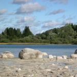
You can talk about it endlessly. It is not for nothing that they say that it is better to see once than to hear 100 times. Dominican Republic (the island of Haiti) is an exotic nature, amazingly beautiful coral reefs, several hundred kilometers snow-white beaches, lakes with emerald water, rivers with crystal clear water, and unruly waterfalls. It has its own history, way of life, unique flavor and friendly people. And by the way, the Dominican Republic is considered the most environmentally friendly place on earth. There is stable atmospheric pressure and the tropical climate is more comfortable than humid. So you can feel great in this area!

Sights of the Dominican Republic
Many people believe that when they come to the Dominican Republic, they will only be able to enjoy beach holidays and sea activities. But in fact there are plenty of things to do here, one of which is sightseeing. Of course, found in this part of the island of Haiti historical places It won’t work out, but the nature is like no other place on the planet.
An interesting village to visit is Altos de Chavon, which is located near Punta Cana. It is themed and stylized as an early colonial settlement. The buildings here are made of stone using old technologies. The village has an amphitheater, which is an exact copy of the Greek architectural structure. The museum features an exhibition dedicated to the pre-Columbian era. She will tell tourists how the Arawak Indians lived before the Europeans came here.
There is a grand museum in the capital. It is called the Columbus Lighthouse and is a huge area where you can find a lot of interesting things, including memorable places. This large building is built in the shape of a cross and is a kind of reminder that America is a Christian state. The most important thing here is the ashes of Christopher Columbus.
Also in Santo Domingo there is a unique museum of its kind, the World of Amber. It presents a large collection of these stones, including very rare specimens. For example, with plants and insects inside, or even blue or red.
Another city worth visiting on the island of Haiti is Puerta del Conde. It was built to protect the capital, and here in 1844 the independence of the Republic was proclaimed. It is a fort, today open to tourists. There is a park behind it, this is a very important place for the patriots of the Republic. They especially value the Altar of Freedom (mausoleum with the founders of the Dominican Republic), which, like other elements of the park, is dedicated to the struggle for independence and freedom.
In honor of the centenary of the recognition of the independence of the Republic, a palace was built, which today serves as the president’s workplace. If you look at the photo of this building, you will notice the resemblance to the White House. And it’s very big.
A list of a few more attractions that are recommended to visit:
- Del Este National Park.
- Captain's Palace.
- Ruins of a Franciscan monastery.
- Ozama Fortress.
- Ruins of the hospital of St. Nicholas of Bari.
- Caves of Los Tress Ojos.
- Church of St. Barbara.

Weather
Speaking about the “behavior” of nature, one cannot help but consider the question of why earthquakes often occur on the island of Haiti. The answer is simple - in this place (that is, in the Caribbean Sea) a displacement occurs earth's crust and geological faults arise, which is why today the territory is recognized as a seismically active zone.
One of the most powerful earthquakes occurred in 2010. And more than once. The first was on January 12th. The epicenter was located 15 km from the capital of the Republic of Haiti, which was very badly damaged, as were its inhabitants. Then they did not give an unambiguous answer about the number of victims - either tens or hundreds of thousands. The magnitude was 7-7.3 points.
The second earthquake on the island of Haiti occurred on February 22, and again in the Port-au-Prince area. Then only 3 people were injured (according to official data), and the magnitude was 4.7 points.
Now about something more pleasant. The climate here is tropical, with relatively humid summers and dry winters. The temperature of water and air practically does not change throughout the year. Moreover, they are also approximately the same among themselves. It is recommended to come to the Dominican Republic in winter, as at this time it is more comfortable here - 26-28 degrees Celsius.

- According to 2010 data, 34.4% of the population lives below the poverty line. But this does not prevent them from remaining friendly and friendly people.
- Rum is considered a particularly popular Dominican product. It combines centuries-old traditions and modern technologies. Twice Ron Barceló Imperial rum was recognized as the best in the world.
- Semi-precious stone is mined here, which is found only in one other place in Spain. Some tourists come just for it. It ranges from bright blue to deep blue.
- Military and police cannot participate in elections.
- Only in the Dominican Republic can you see the Ricordi iguana. She has red eyes, which makes her different from the others.

What will you remember about your vacation?
A holiday on La Españona (the former name of the island of Haiti) will be memorable for everyone, from the gently hugging warm water to the adventures, the most common of which is diving. And what nature is here! Of course, you need to take more pictures so that you can remember the wonderful days and buy souvenirs. They will remind you of the Dominican Republic even more colorfully. Moreover, these souvenirs are unique. For example, high-quality coffee, the best of which is difficult to find in the world, or cognac. A lot of jewelry made of pure gold, amber, and even earrings with larimar. Besides rum, business card countries are also cigars. Painted plates, clay dolls without faces, figurines, shell jewelry, Exotic fruits, carpets self made- you can find anything. The main thing is not to spare money, because these souvenirs are made with love by the residents of the Dominican Republic!
The island of Haiti is located between Cuba and Puerto Rico. It was discovered by Christopher Columbus in 1492, who named it "La Isla Hispaniola", which means "Spanish Island".
At the end of the 15th century, his brother Bartolomeo founded the colony of New Isabella in the southern part ( modern city Santo Domingo). Gold was found in the east, and the poor western third became the possession of France. The French and Spanish colonies were separated by a 375 kilometer border. These colonies later became the Republic of Haiti and the Dominican Republic, respectively. Historically, the neighbors have not had the best relations. Haiti tried several times to conquer neighboring lands, but could not hold them.
By the end of the 17th century, Haiti had become the richest colony in the New World and surpassed North America in exports. Large-scale production of rum, coffee and sugar was established here.
Haiti Island and:
Today, Haiti is the most populous island in the Americas and the 22nd largest in the world. Its area is 76.5 thousand square meters. km, of which 48.4 thousand sq. km occupies the Dominican Republic. The island is known for frequent earthquakes, the last of which occurred in 2010.
The population of Haiti is about 20 million, of which 9.5 million are Dominicans.
The Dominican Republic is more successful than its neighbor. Many illegal immigrants from Haiti move here to work.
The island of Haiti has a humid tropical climate. About 50% of the area is occupied by wet forests, 20% by dry forests. The remaining parts are savannah and wetlands.
Among the animals and birds there are crocodiles, lizards, sea turtles, herons, flamingos and even a black centipede, which poses a great danger to human life. The stung person is paralyzed and rarely survives. However, tourists do not have to worry, since centipedes live far from settlements, in the very depths of the island.

Haitian cuisine is dominated by beans, rice, meat, poultry, corn, fish, vegetables and fruits. Among the most popular dishes:

Rum is the national drink of the entire island, with the addition of which various cocktails and liqueurs are also made.
Haiti
The eastern part is occupied by the Dominican Republic, the island in the western part belongs to the Republic of Haiti - the poor country in America. The average annual air temperature here is 25 degrees, the thermometer can drop to 15 degrees above zero.
The population of the republic often suffers from natural disasters, famine and coups d'etat. The 2010 earthquake killed more than 200 thousand people and caused a cholera epidemic to spread.

The terrible earthquake of 2010 killed 200,000 people.
In the Western Hemisphere, Haiti has the lowest standard of living, so security is very difficult here. Tourists should be very careful, for example, they are not recommended to visit the slums surrounding the main cities such as Cap-Haitien and Port-au-Prince. These areas are controlled by local gangs.Next to criminal Haiti is the Dominican Republic, an island of pleasures and paradise. This is where millions of tourists flock every year.
Dominican Republic
Dominican Republic Haiti- This unique place on earth, the beauty of the landscapes of which will not leave anyone indifferent. It is not for nothing that many couples choose it for their wedding. Photographs taken in the lap of pristine nature can satisfy even a true aesthete.
The exotic nature and richness of the animal world can be seen during numerous excursions that are held for vacationers in the Dominican Republic. Best time to relax in this wonderful place, filled with an incredible atmosphere of silence and bliss, from December to March. It is at this time that weather conditions are most optimal. However, the cost of travel packages is at its peak.

In other months it is also nice to fly to the Dominican Republic, beach holiday available here all year round.
Despite the fact that the Dominican Republic is not the most rich country in America, along its long snow-white beaches, entire chains of fashionable hotels with their own tropical beaches are lined up. The territories of some are so large that they have to be moved around on special trains. Almost all of them have an all-inclusive system, which is especially convenient if you are traveling with children.
Most Big City- Santo Domingo. It has many attractions:
- Cathedral of Santa Maria with the remains of Columbus
- San Francisco Temple
- Church of San Nicolas
- National Library
- Dominican Man Museum
- Modern Art Museum.
Galapagos - an archipelago in Pacific Ocean. The islands are best known for the large number of native species and Charles Darwin's research there, which was the first impetus for Darwin's evolutionary theory of the origin of species.
What does the most beautiful pigeon in the world look like? What was the albatross afraid of? What did the sea lion do to the iguana? This is in the report.
1. This photo was taken to show how the planting process occurs. We got to the islands by yacht; such concrete paths were not everywhere:

2. We witnessed a funny picture. The iguana was swimming about its business, and then the sea lion imposed its communication on it and began to catch it by the tail. This is a little exercise for him, but the lizard is very tense:

3. The iguana was worried more and more every minute; I felt very sorry for her. The lion, having played enough, finally let her go and swam away. The dissatisfied lizard went back to the shore and, it seemed to me, regretted a hundred times that she had started the voyage at all:

4. Iguanas have spots of different colors on their bodies. The color depends on what the lizards eat. Those with a reddish belly prefer algae of a similar color:

5. Bask in the sun:

6. I remembered an interesting legend. The ancient Indians believed that the world was located inside a giant house, and these creatures played the role of its walls:

7. There is a similar shot in the film “Pirates of the Caribbean”. These islands are of volcanic origin. The lava came into contact with water and froze. In some places through holes formed. When contacting a wave, the following effect is obtained:

8. The height of the fountain reached 20 meters, and a rainbow appeared:

9. Eh, it’s a pity I didn’t have time to film the reaction of the seagulls sitting nearby. The poor fellows were seriously afraid and scattered in different directions.

10. Sunbathing:

11. They say it is fashionable to keep them as a pet. Would you have such a pet?

12. We were walking along the path and came across an albatross. By the way, it was isolated as a separate species and called “Galapagos”. He watched us with interest:

13. We walked around the yellow-billed one from the side. He sat, motionless, hatching eggs. Female albatrosses, having put them aside, calmly go about their business, leaving the males to take the rap:

14. And again the iguana. I'm starting to think these lizards are tanning fans:

15. Bird love. A bunch of couples are affectionate with each other:

16. The cute actions continue:

17. By the way, if these comrades take off, the feeling of miniature will disappear as if by hand: their wingspan reaches more than three meters!

18. Blue-footed boobies. During the mating season, they measure the blueness of their paws. The brighter the color, the greater the chance of finding a match:

19. A bird whose exterior resembles our sparrow:

20. The landscape would be absolutely beautiful if it weren’t for the dirty stones:

21. I would like to stay in this place longer and take pictures, take pictures... But, as usual, there was little time.

22. The photo shows the huge wingspan of albatrosses:

23. By the way, they cannot fly up like ordinary birds. Therefore, they dive down from the cliff, pick up speed, spread their wings and only then soar into the sky. Many were afraid to jump down. They shifted in place hesitantly before performing this action.

24. Beautiful:


27. This dove is considered the most beautiful in the world:

28. Coast:

29. Cute Lizard:

30. Backstage:

31. This is the Galapagos, the island of Hispaniola.


Description and location
The island of Espanola is also known as Hood. The island was named Hispaniola in honor of Spain.
The area of the island is 60 sq. km, maximum height 206 m above sea level. The journey from Santa Cruz Island to Hispaniola takes about 10-12 hours.
This is the oldest island of the archipelago, its age is estimated at 3.5 million years. This is also the most south island. Geographically, it is a classic example of a shield volcano, formed by a single caldera in the center of the island. Over time, the island shifted away from the hot spot, the volcano died out and erosion began.
Nature
The island's remoteness from the rest of the group contributes to the high number of endemics on the island and adaptation to the island's natural resources. Iguanas on Hispaniola appear only during the mating season, at which time their reddish hue becomes more green.
The flapping (Galapagos) albatross (Phoebastria irrorata) lives here - rare view birds. The island's steep cliffs provide a perfect landing spot for these large birds, which feed off the coasts of Ecuador and Peru. The hooded mockingbird is also one of the island's endemic species. These bronze birds are not at all afraid of people and often land on the heads and shoulders of tourists in search of food.
Visitors can also encounter brightly colored marine iguanas, lizards, gulls, gannets, Galapagos hawks and finches. And large bays with sand and small pebbles attract large numbers of sea lions.
Interesting places
Hispaniola has two visitor sites: Gardner Bay and Punta Suarez.
Gardner Bay is located in the northeastern part of the island and offers a stunning, long, white sand beach, where colonies of sea lions lazily bask in the sun, sea turtles come ashore and curious mockingbirds scurry about. The beach is considered an open area that you can explore freely. It has nice beach and a place for swimming and diving.
Gardner Bay is a fantastic place for snorkeling. This may be your only chance to swim with sea lions, don't miss it. Closer to Turtle Rock and the Gardner Islands there are large colonies of colorful tropical fish such as yellowtail surgeonfish, king angelfish, and parrotfish. A manta ray glides through the waters and whitetip sharks doze at the bottom.
Punta Suarez is located in the western part of Hispaniola. The Punta Suarez area offers wildlife viewing with a wide variety of local fauna. This sea lions, seabirds, large marine iguanas and colored lava lizards.
Excursions and attractions
Gardner Bay
Resort oriented on: adults.
Resort specifics: natural-cognitive.
The island of Hispaniola, one of the most famous resorts world, is very popular among tourists. Various types of recreation and excursion programs one of the main components modern holiday. Like most resorts in the world, Hispaniola Island can provide different levels of relaxation at a variety of prices. This resort has both luxury hotels and budget hotels.
If you are tormented by the question “Where to relax?”, “Where to spend your vacation?” Then perhaps Hispaniola Island will be the perfect holiday destination.
Map of the island of Haiti (Hispaniola).
The island of Haiti (in some sources – Hispaniola) is the second largest island in the Greater Antilles archipelago, located approximately 100 kilometers east of and approximately the same distance west of the island of Puerto Rico. The island of Haiti is washed by the open Atlantic Ocean to the north and the Caribbean Sea to the south. The word "Haiti" comes from a phrase in the language of the Taino Indians, translated as "Mountain Country". The second name – Hispaniola (La Española) was assigned to the island by Christopher Columbus and is literally translated into Russian as “Spanish”.
Definition geographical coordinates of the island of Haiti is made according to its conventional geographical center: 19°00′ N. w. 70°40′w. d.
The area of the island of Haiti and other small islands and rocks adjacent to it is approximately seventy-six and a half thousand square kilometers.
IN this moment on the island of Haiti there are two states: the Republic of Haiti (in the western part of the island) and the Dominican Republic (in the eastern part), which in a number of sources is also called the Dominican Republic or the Dominican Republic.

Southern coast of the island of Haiti.
Story.
The island of Haiti was discovered during the expedition of Christopher Columbus in 1492, receiving the name Hispaniola, after which its colonization by the Spaniards began. During colonization, the indigenous population of the island, represented by the Taino Indians, was practically exterminated.
In 1667, the western part of the island officially came under French control, while at the same time the Spaniards strengthened in the center and west, calling their part of the island Santo Domingo. During this period, both France and Spain began to import slaves from Africa to the island to work on plantations and in mines.
In 1803, a slave revolt broke out in the French part of the island of Haiti under the leadership of Jean-Jacques Dessalines, which spread to the eastern part. The result of the uprising was the proclamation of the independence of the Republic of Haiti in the western part on January 1, 1804 and the expulsion from the island of the Spaniards, who were able to regain control of Santo Domingo only in 1808, and even then, only for a short period.
In 1822, another uprising breaks out in Santo Domingo local population against the Spaniards, which ends with the final liberation from Spanish rule. However, almost immediately East End The islands are occupied by troops of the Republic of Haiti.
In 1825, after delays, France recognized the independence of the Republic of Haiti, but on the condition that it pay a huge indemnity for the loss of property of the French living on the island at that time.

Levantado Reef in the north of Haiti in Samana Bay.
In 1844, after a successful anti-Haitian uprising in eastern and central parts islands, the independent Dominican Republic is proclaimed.
In 1905, exhausted by the confrontation with Spain and internal contradictions, the Dominican Republic became financially dependent on the United States.
From 1915 to 1934, the Republic of Haiti was occupied by US troops. The occupying forces bring to power in the country a government representing the mulatto minority. In 1916, the American occupation befalls and Dominican Republic after the assassination of the country's president.
During World War II, both the Dominican Republic and the Republic of Haiti entered the war on the side of the Anti-Hitler coalition, but their participation became more than a formality.
In 1957, the Duvalier family clan of dictators comes to power in the Republic of Haiti. The last representative of this dynasty, Jean-Claude Duvalier, was overthrown after popular unrest in 1986.
In 1965, after a pro-Soviet coup in the Dominican Republic, the United States once again occupied this country, establishing its democratic power.
At the beginning of the 21st century, the political situation in the Dominican Republic stabilized somewhat, and the country’s financial and economic indicators improved. At the same time, in the Republic of Haiti, numerous coups, popular unrest and foreign interventions have thrown the country back to the position of one of the poorest countries in the world.

A bay in the southwest of the island of Haiti.
Origin and geography of the island.
The island of Haiti, like the neighboring islands of Cuba, Jamaica and Puerto Rico, is the surface part of the North Caribbean underwater mountain range, which rose at the boundary of the collision of three geological plates. Therefore, experts classify all the islands of the Greater Antilles as volcanic. Their formation dates back to approximately the early Miocene period, and their age is estimated at approximately 6-7 million years.
To the west of Haiti across the Windward Strait lies the island of Cuba, to the east from Haiti it is separated by the Mona Strait, and to the southwest from the island of Jamaica by the strait of the same name. In the northwest of the island of Haiti and the Great Iguana ( Bahamas) are separated by a fairly wide Foster Strait.
The island of Haiti has a complex geometric shape. The coastline winds strongly along its entire length, forming numerous bays and bays of varying sizes. Among the most significant bays washing the island, it is worth highlighting the Gulf of Gonave (on west coast), Samana (in the northeast) and Deverger (in the south).
Off the coast of Haiti there are several inhabited and uninhabited islands and rocks, among which it is worth noting Gonave (in the Gulf of Gonave), Tortu (off the northwest coast), (USA) and Vash (off the southwest coast), Saona and Mona (off the east coast and in the Mona Strait).
The relief of the island of Haiti in its central and western parts is predominantly mountainous, and only in the west and southwest do flat lowlands stretch in a narrow strip from north to south. Four massive mountain ranges stretch in the direction from east to west of the island, the largest of which is the Cordillera Central (Cordillera Central), where the highest point both Haiti and the entire Antillean archipelago - Mount Duarte Peak, 3087 meters above sea level. In the south of Haiti, beyond the low-lying Cibao Valley, the mid-elevation Central Plateau and the shallow Cul de Sac depression, stretch the mountain ranges of Sel, Haut, Sierra de Bauroco, Mato and Sierra de Neiba. In the northern part of the island, it is worth noting the Northern ridges, which are a continuation of the Central Cordillera, the medium-high Cordillera Oriental and the rather high (about 1200 meters) Cordillera Septentrional.
The rivers on the island of Haiti are deep and full-flowing, but not long. Among the most significant rivers of the island is Artibonite, which flows in the west and flows into Atlantic Ocean, Yaque del Norte in the northern part of the island and Osamu, which flows into the Caribbean Sea in the south. In addition to rivers, there are quite a lot of lakes in Haiti, the largest in area are Enriquillo (in the border areas of the Dominican Republic and the Republic of Haiti), as well as Somatre (in the central part of the island).
The coast of Lake Enquillo.
Climate.
The climate on the island of Haiti should be classified as tropical trade wind type. The air temperature does not fluctuate significantly depending on the time of year. On the coast of the island, the weather is consistently warm with a temperature of + 22-27 degrees. In the interior of the island, in areas protected from the trade winds, the temperature can even rise to +30-35 degrees. Almost the entire territory of the island receives quite a lot of precipitation in the form of tropical downpours throughout the year. The greatest amount of precipitation falls between early June and mid-December. On average, over a year, on the slopes of mountain ranges located in the path of sea trade winds, sometimes more than 2000 millimeters fall, and in the middle part of the island and mountain valleys - about 400-1100 millimeters. Between the beginning of August and the end of September, the island is most likely to experience hurricanes and typhoons originating in the central Caribbean Sea.

The La Esperilla district in the capital of the Dominican Republic, Santo Domingo.
Population.
According to UN data as of 2013, more than 20 million people lived throughout the island of Haiti, of which about 9.2 million were in the Republic of Haiti and about 11 million in the Dominican Republic. By ethnic composition The population on the island is unevenly distributed. Thus, in the Republic of Haite, the Negroid population makes up more than 95% of the total number living in the country, while mulattoes and whites account for only about 5%. In the Dominican Republic, mulattoes predominate (73%), while whites and blacks make up approximately 27% in approximately equal proportions. State languages in the Dominican Republic it is Spanish, and in the Republic of Haiti it is French and Haitian Creole, which is a modified French.
The capital of the Republic of Haiti is the city of Port-au-Prince, located on the shores of the Gulf of Gonave and populated by almost nine hundred thousand inhabitants. At the same time, the capital of the Dominican Republic is the city of Santo Domingo, located in the south east coast islands and has a population of more than 2 million people. Among the large settlements on the island of Haiti are the cities of Delmas and Carrefour (Republic of Haiti), as well as Santiago (Dominican Republic).
The form of government in both the Republic of Haiti and the Dominican Republic is a presidential republic with a legislative body - parliament.
National monetary units The Dominican Republic and the Republic of Haiti are respectively the Dominican Peso (DOP, code 214) and the Haitian Gourde (HTG, code 332). However, in both countries, both the US dollar and the euro are accepted quite freely as means of payment.

The village of Cap-Haitien in the Republic of Haiti.
Flora and fauna.
The flora of the island of Haiti is represented mainly by evergreen massive tropical forests, where more than 100 species of woody plants grow. Among them, it is worth noting logwood, rosewood, rambi and yamasin palms, which are native to the island. On the slopes of the Cordillera Central mountain range there are significant areas of coniferous-hard-leaved forests, in the central regions of Haiti there are deciduous forests, where, in addition to woody plants, quite a lot of shrubs grow.
The fauna of Haiti, like other Caribbean islands, is not very diverse. Mammals here are represented only by domestic animals, bats and rodents. There are always a lot of birds on the coast of Haiti and the coastal islands, and in the central regions of the island, especially in the areas of rivers and lakes, there are a large number of reptiles, among which crocodiles and lizards predominate.

A typical beach on the east coast of the Dominican Republic.
Tourism.
Despite the fact that natural conditions are almost the same both in the west of Haiti and in the east; tourism is developed only in the Dominican Republic. All last-minute holiday tours in the Dominican Republic (as well as in other resorts on Earth) are provided by the hottours.in.ua agency, which guarantees its clients maximum convenience and service when traveling to various countries.
The prospects for the development of tourism in the Republic of Haiti are undermined by the unstable political situation in the country and the increased, especially in Lately, crime situation.
As for the Dominican Republic (Dominican Republic), everything is done for tourism here, since it has long become a prevailing sector of the national economy. Almost the entire coast of the country is divided into resort areas operating autonomously from other territories of the country. These include airports, sea ports, a chain of hotels of various classes and beach complexes. Both residents of the USA and Canada, as well as Europe, visit the resorts of the Dominican Republic quite willingly. Over the past three years, the flow of tourists visiting the Dominican Republic has tripled and now amounts to 120 thousand people a year.

One of the beaches on Caribbean coast Dominican Republic